Depression in East Sea to strengthen into storm
Tuesday, September 17, 2013, 09:40 GMT+7

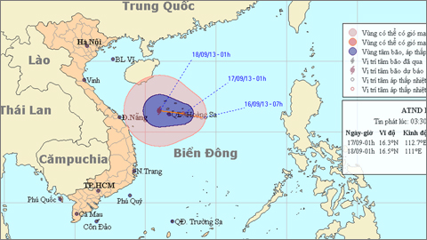
The tropical depression currently located in the East Sea with winds of up to 56 kph is likely to develop into a storm soon, the National Hydro-Meteorological Forecasting Center reported. At 1 am this morning, September 17, the depression was centered at 16.3 degrees latitude north, 112.7 degrees longitude east, in an area east-southeast of the Hoang Sa (Paracel) archipelago, with winds of 39-61 kph and gusts of 62-88 kph. The storm is moving west-northwest at a speed of about 5-10 kph. At 1 pm today, it will sit at 16.6 degrees latitude north, 111.4 degrees longitude east, west of Hoang Sa, with unchanged wind speeds. The depression will likely strengthen into a storm within a few days and affect the coastal region from northern Ha Tinh to Phu Yen Provinces, said Le Thanh Hai, the center’s deputy director. At 1 am Wednesday the depression will be located at 16.5 degrees latitude north, 111.0 degrees longitude east, with maximum winds of 74 kph and gusts of 75-102 kph. Due to the depression, medium to heavy rains will occur in the region from central Nghe An to Quang Ngai Provinces from September 18 to 21. Flashfloods and landslides may occur in mountainous areas. The depression will also strengthen the southwest winds, spreading rain from the south-central region to the Central Highlands and southern provinces, Hai said. Due to the depression, the coastal area from Binh Thuan to Ca Mau Provinces and the southern area of the East Sea, including the Truong Sa (Spratly) archipelago, will have rough seas and winds of 39-49 kph and gusts of 50-74 kph. Rains and thunderstorms will affect these areas.
Meanwhile, thunderstorms will also hit northern Vietnam, especially in delta provinces and northeast coastal provinces, the center said.

Masuo Ono, Japanese Consul General in Ho Chi Minh City, affirmed that the support from local authorities and the partnership between Vietnamese and Japanese firms will contribute to sustainable development in the province

An Australian businessman, John Koon, accused her of defrauding him of a total of $3.2 million
1 day ago
She developed symptoms of hard, wavy, scaly, gray skin, mainly on her wrists, elbows, knees, ankles, armpits, back of hands, and insteps, as well as full-body dry skin
2 days ago
Many delivery workers are spotted using their phones while driving, posing a high risk of traffic crashes
2 days ago
Up to 404 trees are slated to be cut down, while the remaining trees will be transplanted
1 day ago
The foul smell from the contaminated channel permeates almost every corner in the area
1 day ago
The two sides are committed to preventing visa abuse, increasing intelligence sharing, and continuing the process of returning those with no right to remain in the UK


He drew the virus, vaccine, and earth on the exterior walls of a house

The two sides are committed to preventing visa abuse, increasing intelligence sharing, and continuing the process of returning those with no right to remain in the UK

From the end of March until now, Odom has produced many interesting vlogs in which she converses with food vendors in English, showcasing her interactions with local cuisine

Widespread stick-on ads are a headache for not only Da Nang City but also other major cities in Vietnam

The company was also required to undertake corrective actions

She managed to stage a good performance and cross the finish line in 2:18.178 minutes

This special tour will give tourists experiences of sightseeing in the ancient town and reaching different destinations by boat on high-water days

Dubai International Airport, a major travel hub, struggled to clear a backlog of flights and many roads were still flooded in the aftermath of Tuesday's deluge

The taxi moved backward and narrowly avoided a collision with another car

The rather cool weather accompanied by scattered showers in the northern region will probably give way to a heatwave

This is the first Vietnamese film to secure the top prize at an Asian Film Festival in Italy


