Historic landmarks along Vietnam’s backbone entice offroad tourists
Monday, March 17, 2014, 15:12 GMT+7

Historic landmarks on the road that runs along the Truong Son mountain chain now entice offroad tourists, especially the section running from the central region to the north.
These landmarks are the last remaining traces of the trail used to transport ammunition and food supplies from the north of Vietnam to the south during the war against the U.S.
To avoid bombs dropped by U.S. military planes, Vietnamese supply soldiers had to hide in forests and find ways to surpass mountain peaks to carry goods to their destinations.
After decades, the trail was established, known as the Ho Chi Minh Trail. Now it is part of the Truong Son Highway.
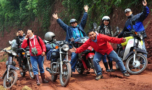
The venues along the trail have grown in appeal for curious travelers who wish to visit historic places along the border with Laos, understand the life of border guards, and experience the lifestyle of the ethnic minorities who live in scattered villages along the trail.
To penetrate the villages, explorers must drive motorbikes on the small “branch roads” that cross the Truong Son Highway.
The start
Tuoi Tre journalists began a journey this month at the Indochina crossroads, the intersection of Vietnam, Laos, and Cambodia.
This intersection, in Ngoc Hoi District of the Central Highlands province Kon Tum, is 1,086m above sea level.
The team made a journey of over 2,000km from the point to cross ten border provinces and 834 border posts.
Several hundreds of meters from Ngoc Hoi is the first border post, Bo Y, which is guarded 24 hours a day by Vietnamese soldiers who are stationed in a temporary hut without electricity or water. The area is completely uninhabited.
The team drove on a concrete road 3.5m wide to head towards Quang Nam Province.
Milestones along the road bear no information regarding their distance from each other, and are marked only with border post names such as “Dak Su,” “Dak Glong,” and “Duc Nong.”
Thus, travelers only know what the next border post is, not where it will be.
Captain Pham Duc Chien told Tuoi Tre, “Here, what we consume most is cotton wool. It is used to filter drinking water from poisonous remnants left in the ground from wartime.”
Having no electricity, the border soldiers have to charge their mobile phones by connecting them to the ‘source energy’ made of three A size batteries for over an hour.
“But this method quickly degrades phone batteries,” he added, saying that the only means of entertainment for soldiers is a portable radio. Soldiers are at risk of infecting malaria, which causes a fever for weeks.
The height of the hilly slopes in their patrolling zone is not calculated by meters, but by how many times they need to rest while climbing to the peaks. The soldiers thus refer to them as ‘five-rest slopes’ or ‘seven-rest slopes’.
Some slopes are as steep as 45 degree angles. Most border posts that demarcate the border between Vietnam and Laos are planted on Truong Son peaks.
On visiting border post 777 managed by the Duc Nong border station, the Tuoi Tre journalists were told by a soldier that it was the first time he had ever received guests at the site.
Leaving behind the branch road, the team turned to the Truong Son Highway to continue their journey to Dien Bien Province to the north.
Mountain pass Lo Xo, known as one of the most perilous sections of the trail, welcomed the team with a forest rain that lasted many days.
It was rare to see the light of any vehicles driving in the opposite direction.
Visiting a blind ammunition bearer
The bearer is Alang Bhuoc, 83, of the ethnic minority people Co Tu. Although he lost his ability to see at the age of 10, Bhuoc carried a total of 182,000 kg of ammunition and food for the Vietnam People's Army from 1958-72 and crossed numerous mountain peaks along the Truong Son trail.
He and his wife now reside in Aruung Hamlet, Bhalee Commune, in Tay Giang District of Quang Nam Province.
Bhuoc recalled that he could carry 50-60kg of cargo, finding his way thanks to a walking stick and listening to the sound of those walking ahead of him.
He was awarded many medals for his bravery and assistance to war efforts.
The team surpassed many famous passes such as Sa Mu, located in the central province of Quang Binh, with a total length of 24km at a height of 1,400m above sea level.
Provincial residents call it the God Gate because of its height and the permanent fog and clouds that obscure it.
During wartime, Vietnamese soldiers had to make a detour of 30km into Laos before returning to Vietnam to avoid the God Gate due to its danger.

Agricultural products remain Vietnam’s key export earner

From the end of March until now, Odom has produced many interesting vlogs in which she converses with food vendors in English, showcasing her interactions with local cuisine
6 hours ago
'A carton of eggs now costs ¥400 [US$3.64] instead of ¥200 [$1.82] like before'
1 week ago
Three children live alone without parents
5 days ago
Many have died from excessive drug use and health damage
3 years ago
It's not a joke!
9 months ago
The two sides are committed to preventing visa abuse, increasing intelligence sharing, and continuing the process of returning those with no right to remain in the UK


He drew the virus, vaccine, and earth on the exterior walls of a house

The two sides are committed to preventing visa abuse, increasing intelligence sharing, and continuing the process of returning those with no right to remain in the UK
From the end of March until now, Odom has produced many interesting vlogs in which she converses with food vendors in English, showcasing her interactions with local cuisine

Widespread stick-on ads are a headache for not only Da Nang City but also other major cities in Vietnam

The company was also required to undertake corrective actions

She managed to stage a good performance and cross the finish line in 2:18.178 minutes

This special tour will give tourists experiences of sightseeing in the ancient town and reaching different destinations by boat on high-water days

Dubai International Airport, a major travel hub, struggled to clear a backlog of flights and many roads were still flooded in the aftermath of Tuesday's deluge

The taxi moved backward and narrowly avoided a collision with another car

The rather cool weather accompanied by scattered showers in the northern region will probably give way to a heatwave

This is the first Vietnamese film to secure the top prize at an Asian Film Festival in Italy


