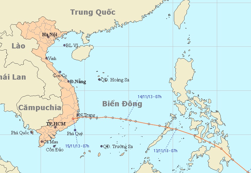
After entering the waters off Vietnam’s south central region between Phu Yen and Binh Thuan provinces, storm Podul has weakened into a tropical depression and will likely strike the region this morning, the National Center for Hydro-Meteorological Forecasting reported.
At 4 am ICT today, November 15, the depression was centered at 12.0 degrees latitude north and 109.8 degrees longitude east in the waters off the Phu Yen-Binh Thuan region, with winds near the eye reaching up to 61 kph, and squalls of 62-88 kph.
The depression is moving west-southwest at a speed of 25 km, heading for the coast of Khanh Hoa-Binh Thuan and will hit the region this morning before weakening into a low pressure system. At 4 am Saturday, the system will be centered in an area in Cambodia, with winds of less than 39 kph. Due to the depression, from this morning the waters off the region between Binh Dinh and Binh Thuan provinces will experience rough seas and winds as strong as 61 kph and gusts up to 88 kph. At the same time, medium and heavy rains will occur in a wide area stretching from mid central provinces to the Central Highlands, while southern provinces will have medium rains, but in some areas torrential rains and thunderstorms may occur.
From this afternoon, the waters off the Binh Dinh-Binh Thuan coast will be rough, with winds of 39-61 kph and squalls of 62-88 kph. Meanwhile, due to impacts of a strengthened cold front, the Gulf of Tonkin will have northeast winds as strong as 49 kph, and squalls of 61 kph. Yesterday the Central Steering Committee for Flood and Storm Prevention and Control and the National Committee for Search and Rescue sent urgent messages to local authorities in the region from Quang Tri to Ninh Thuan Provinces as well as the Central Highlands, asking them to take effective measures to cope with the landfall of the depression. The Ho Chi Minh City Steering Committee for Flood and Storm Prevention has banned all boats from going to sea from 12 am Friday, November 15.


