East Vietnam Sea survey team – P1: Tidal check
Friday, November 20, 2015, 10:25 GMT+7

Mapping the bottom of the East Vietnam Sea for scientific research, construction, and other work of the Vietnamese navy is the mission of the 6th naval squad.
Tuoi Tre (Youth) newspaper journalists had a chance to go aboard the ship 884 to survey the seabed in preparation for the construction of an aerial electricity grid to connect the mainland with Lai Son Island in the Pirates’ Archipelago in the western sea of Vietnam.
The grid is 25km long and the longest one of its kind in the country.
The project is expected to start supplying electricity to 8,200 people of 2,000 households by the Lunar New Year of 2016, in three months’ time.
Preparation for an offshore journey
The length of a journey to survey the seabed of the 6th squad is not often fixed and can be dependent on weather conditions. A short trip may last one or two months but this can stretch out for up to half a year or more.
The journalists were given an appointment at a small port in Ha Tien in the southwest of Vietnam.
Some of the staff on the ship, who had been dropped there to complete their regular tidal-check mission at the port, along with the Tuoi Tre journalists were carried to the 884 ship anchored some six nautical miles offshore.
They were forced to wait for several days because of high waves despite the short distance from the coast to the 884 ship.
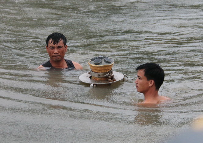
The job of the tidal-check team is to drop special equipment at certain locations along the coast which can record information about the height and time of tide and sea currents.
The equipment had been dropped at Ha Tien coast 17 days earlier.
In addition, members of the staff use manual measurements along with the automatic equipment to record the most accurate data.
“Manual measurements are always necessary in special cases. Automatic equipment may not be accurate in rough seas with the height of waves reaching several meters,” said Captain Pham Van Quang, head of the measurement unit of the ship 884.
A tidal-check team often has three members who take turns to go on daily duty, each for an eight-hour shift to record tidal data every 30 minutes.
They are the staff members who mostly leave their ship to go ashore. The biggest challenge of the team onshore is the lack of electrical power to capture data into computers that are required to operate nearly permanently.
Dropping a shark
After collecting tidal-check equipment, the team headed toward the ship 884 to begin a true journey surveying the seabed.
Captain Quang said the job of sea measurement is extremely challenging during rough seas, from late autumn to early spring in the western sea of Vietnam.
Automatic equipment does not work effectively under rough seas with waves rising several meters in height.
A day on the ship starts at 5:00 am after three calls of the siren. Soldiers have half an hour for breakfast and to wash.
Technicians carry a big box of equipment on deck.
Nguyen Van Dai, a technician and first lieutenant on the ship, said, “The box keeps a ‘shark.’
“It is an automatic shark, worth billions of dong.” (VND1 billion = US$44,500)
The shark is around two meters long, as big as a human calf, and made of stainless steel.
It has fins to keep balance. Fins on the back atop the shark are connected with cables and other electronic wires.
“This robotic shark is very intelligent. It can scan the entire terrain of the seabed by emitting rays,” said Captain Quang.
“Data we receive back is transmitted to computers aboard the ship.”
The shark is let out into the ocean by a crane on the dock of the ship. It is connected with the ship by a steel wire and slowly dragged behind the vessel.
In the cabin, Captain Vu Trong Phu said his ship will run back and forth on routes close to one another like a farmer ploughing parallel furrows in his field in order to scan the entire seabed of the area.
“At the sea depth of 100 meters, the robot can scan on average a width of 400-600 meters,” Captain Phu said while holding in his hands a map of the area of the seabed to be surveyed on the day.
“In some places, it can survey a width of 800 meters, depending on the terrain of the seabed.
“This shark can work at a depth of 1,500 meters.”
He added that it is difficult to scan an area of seabed with hills and mountains and rock pillars since the complicated terrain may cause damage to the electronic robot.
Like us on Facebook or follow us on Twitter to get the latest news about Vietnam!

The Vietnam-South Korea defense cooperation has achieved pragmatic, outstanding outcomes

From the end of March until now, Odom has produced many interesting vlogs in which she converses with food vendors in English, showcasing her interactions with local cuisine
6 days ago
Many have died from excessive drug use and health damage
3 years ago
Three children live alone without parents
1 week ago
Balut, shrimp paste, pig brain, and duck blood soup are just a few of the foods featured in this American foodie’s reviews of Vietnam
6 years ago
The current national rail network in Vietnam lags behind those of neighboring countries in Southeast Asia
4 months ago
He will spend VND10 trillion (US$394 million) from his pocket building charging stations in the next three years


He drew the virus, vaccine, and earth on the exterior walls of a house

He will spend VND10 trillion (US$394 million) from his pocket building charging stations in the next three years

The land lots will be used for the Rach Tram high-end eco-tourism and residential area project

It features a wide range of product lines from Vietnam and other Asian countries

The ring provided loans topping VND20 trillion (US$790 million) at an annual interest rate of 2,346 percent to more than one million people

The number of children dying from vaccine-preventable causes in Vietnam has reduced significantly since 1981

The facility owner was confirmed to have abused children

TikTok Shop’s turnover increased 15.5 percent over the last quarter of 2023

The firm intends to invest VND630-650 billion (US$24.8-25.6 million) in purchasing 700 hybrid cars

The hailstorm in Van Ho District, Son La Province lasted about one hour

Japan, the world's fifth-largest emitter of greenhouse gases, covers a surface area smaller than California but has some of the longest coastlines in the world


