World Atlas affirms Vietnam’s sovereignty over Hoang Sa, Truong Sa archipelagos
Thursday, May 15, 2014, 17:03 GMT+7

The Ministry of Information and Communications held a ceremony on Tuesday to receive and announce the “Atlas Universel de Geographie” (World Atlas of Geography) by a French geographer published back in 1827, which proves Vietnam’s sovereignty over its Hoang Sa (Paracel) and Truong Sa (Spratly) archipelagos.
>> Vietnamese ship hits back at 15 Chinese vessels with water cannon
>> Vietnamese force never wavers despite Chinese attacks
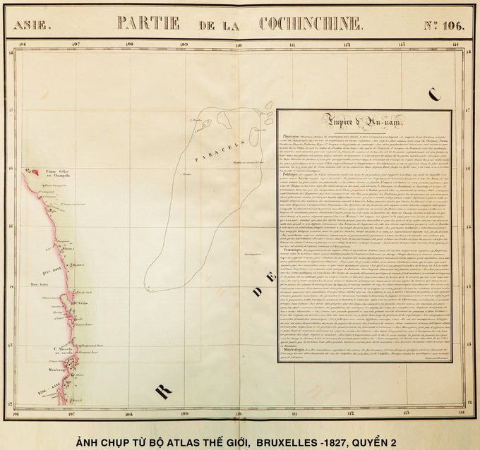
The atlas, created by Belgian geographer/ cartographer Philippe Vandermaelen (1795-1869), features the “Partie de la Cochinchine,” which asserts Vietnamese ownership of Hoang Sa and Truong Sa.
Out of its six volumes, Volume 2, comprised of 11 sheets, features Vietnam through maps numbered 97, 105, 106, and 110.
Map number 106, called “Partie de la Cochinchine,” depicts the central coastline spanning from Latitudes 12 to 16.
Hoang Sa is also described precisely from Latitudes 16 to 17 and from Meridians 109 to 111.
In the map, the Hoang Sa archipelago is comprised of such islands as Pattles and DunCan to the west, Tree and Lincoln and Rocher au desus de l’eau to the east, Triton to the southwest, and Invertigateur to the south.
Apart from the Hoang Sa archipelago, the map also features a summary on the “Empire d’An-nam” (Empire of An Nam).
Map number 98, called “Partie de la Chine,” which features China’s Guangdong Province and Hainan Island, proves that China’s southernmost frontier did not reach Latitude 18.
The “Partie de la Cochinchine” is the first international map to precisely feature the coordinates, geographical characteristics, and Western names of the Hoang Sa archipelago’s key and largest islands.
The map is strongly indicative of Vietnam’s sovereignty over the archipelago.
The Atlas was created based on the world’s best maps back then, astrological observations, and findings obtained during journeys around the globe.
It was drawn coherently in the 1/1,641,836 ratio, and boasts 53.5x37cm maps, which can combine to build a 7.755m-in-diameter generic globe.
Philippe Vandermaelen’s “Atlas Universel” consists of seven generic maps of five continents, 381 conically projected maps, 40 pages of statistical tables, and information on geography, politics, and mineral reserves in six volumes.
Philippe Vandermaelen was an eminent Flemish cartographer and geographer.
He was believed to be one of the founding members of the School of Geography at Molenbeek Brussels, now known as the Military Geographical Institute, Brussels.
Vandermaelen involved himself in creating and publishing maps and extensively used the metric system to determine the scales on his maps, resulting in high-level scientific accuracy.
His Map of Belgium, which was published in 1866 and is still used as a guide, is an outstanding example of such accuracy.
Vandermaelen’s “Atlas Universel de Geographie” was spotted by a Vietnamese graduate student in France at a Sanderus bookstore, which sells time-honored books in Gent City in Belgium.
Ngo Chi Dung, CEO of ECO Pharma Co., sponsored all research on the Atlas in national libraries in France and Belgium, as well as extensive discussions with French and Belgian experts to verify that the Atlas is the original that was published in Brussels back in 1827.
Upon the origin verification, the Atlas was purchased and brought to Vietnam to cement the historical and legal evidence of Vietnam’s sovereignty over the Hoang Sa archipelago.
The receipt and announcement of the Atlas is part of the country’s activities to boost the collection and use of materials and maps related to Vietnam’s sovereignty over Hoang Sa and Truong Sa.
Other maps affirming Vietnam’s sovereignty over Hoang Sa and Truong Sa
Starting in the 16th century, several Western maps featured the Indies or East Indies (or East India), which include the lands of South and Southeast Asia, including Vietnam, as having Hoang Sa in the East Vietnam Sea, and marking the coastline to the west of Hoang Sa (the central Vietnamese coast) as Costa de Paracels (Coast of Paracels).
During the 17th and especially 18th centuries, more maps clearly indicated the position, geographical features, and relationship of Hoang Sa to “Dang Trong” (Inner Half – an area of Vietnamese southward expansion in the past).
However, most of these maps still included Hoang Sa in the Indies or East Indies.
Not until the early 19th century—when the Nguyen Dynasty (1802-1945), Vietnam’s last monarchy, was formed and fully asserted Vietnamese sovereignty—did Western maps officially recognize Hoang Sa as belonging to Vietnam.
All Chinese maps from the early 20th century are also coherent with their Western counterparts in that they never feature China’s southernmost frontier crossing beneath Latitude 18.
In the past several days, Vietnamese people at home and abroad have been expressing solidarity in protesting against the illegal deployment of a giant oil rig by China in Vietnamese waters in the East Vietnam Sea early this month.
Several countries have also backed Vietnam’s stance on the East Vietnam Sea.

The foul smell from the contaminated channel permeates almost every corner in the area

Vietnam is very interested in the canal project
1 week ago
President Diaz-Canel remarked that the Cuba-Vietnam relations are special, with both nations always showing great respect for each other
2 days ago
The two sides are committed to preventing visa abuse, increasing intelligence sharing, and continuing the process of returning those with no right to remain in the UK
2 hours ago
Yunnan will also strengthen cooperation in the fields of infrastructure, green and modern agriculture, green energy, healthcare
5 days ago
The ambassador was dismissed in May for a breach of anti-graft legislation and other irregularities
4 years ago
The two sides are committed to preventing visa abuse, increasing intelligence sharing, and continuing the process of returning those with no right to remain in the UK


He drew the virus, vaccine, and earth on the exterior walls of a house
The two sides are committed to preventing visa abuse, increasing intelligence sharing, and continuing the process of returning those with no right to remain in the UK

From the end of March until now, Odom has produced many interesting vlogs in which she converses with food vendors in English, showcasing her interactions with local cuisine

Widespread stick-on ads are a headache for not only Da Nang City but also other major cities in Vietnam

The company was also required to undertake corrective actions

She managed to stage a good performance and cross the finish line in 2:18.178 minutes

This special tour will give tourists experiences of sightseeing in the ancient town and reaching different destinations by boat on high-water days

Dubai International Airport, a major travel hub, struggled to clear a backlog of flights and many roads were still flooded in the aftermath of Tuesday's deluge

The taxi moved backward and narrowly avoided a collision with another car

The rather cool weather accompanied by scattered showers in the northern region will probably give way to a heatwave

This is the first Vietnamese film to secure the top prize at an Asian Film Festival in Italy


