Storm Krovanh brings turbulent seas to southern Vietnam
Monday, December 21, 2020, 15:01 GMT+7

Storm Krovanh formed from a tropical depression in the East Vietnam Sea on Sunday and is now heading toward the maritime area off southern provinces, according to the National Center for Hydro-meteorological Forecasting.
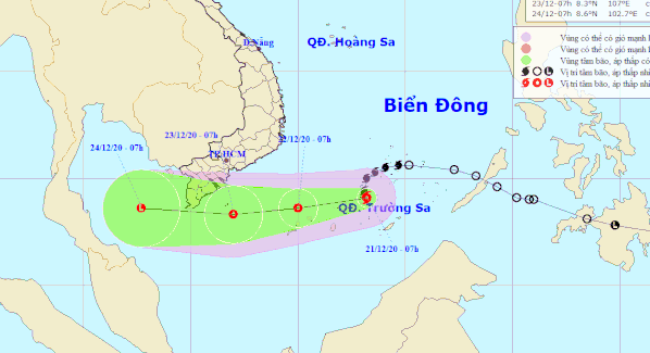
The storm, the 14th to hit Vietnam in 2020, was located at 270 kilometers northeast of the Huyen Tran (Alexandra) Bank within Vietnam's Truong Sa (Spratly) archipelago as of 7:00 am on Monday, packing wind speed of 60-75km per hour.
It is expected to travel southwest in the next 24 hours and weaken into a tropical depression.
By 7:00 am on Tuesday, the low-pressure system will have been located at 100 kilometers northwest of Huyen Tran Bank.
Average wind speed will decrease to between 40km and 60km per hour.
By Wednesday morning, the tropical depression will have been at 80 kilometers southeast of Con Dao Islands off the southern province of Ba Ria-Vung Tau, with winds at 40-50km an hour.
It will travel west in the next 48 to 72 hours and continue to weaken.
Due to the storm circulation, rough seas, high waves, and rain will occur in the central and southern sections of the East Vietnam Sea in the coming days.
As the storm will weaken at sea, it will not have big impacts on the weather in the mainland, Mai Van Khiem, director of the National Center for Hydro-meteorological Forecasting, said at a meeting with the national steering committee for natural disaster prevention on Monday morning.
From Tuesday, rainfall of 30-70 millimeters will dampen southern localities, Khiem added.
About 2,000 fishing boats operating in the affected areas have been advised to take shelter during this period.
Like us on Facebook or follow us on Twitter to get the latest news about Vietnam!

The foul smell from the contaminated channel permeates almost every corner in the area

An Australian businessman, John Koon, accused her of defrauding him of a total of $3.2 million
1 day ago
She developed symptoms of hard, wavy, scaly, gray skin, mainly on her wrists, elbows, knees, ankles, armpits, back of hands, and insteps, as well as full-body dry skin
1 day ago
Many delivery workers are spotted using their phones while driving, posing a high risk of traffic crashes
2 days ago
Up to 404 trees are slated to be cut down, while the remaining trees will be transplanted
1 day ago
The foul smell from the contaminated channel permeates almost every corner in the area
1 day ago
From the end of March until now, Odom has produced many interesting vlogs in which she converses with food vendors in English, showcasing her interactions with local cuisine


He drew the virus, vaccine, and earth on the exterior walls of a house

From the end of March until now, Odom has produced many interesting vlogs in which she converses with food vendors in English, showcasing her interactions with local cuisine

Widespread stick-on ads are a headache for not only Da Nang City but also other major cities in Vietnam

The company was also required to undertake corrective actions

She managed to stage a good performance and cross the finish line in 2:18.178 minutes

This special tour will give tourists experiences of sightseeing in the ancient town and reaching different destinations by boat on high-water days

Dubai International Airport, a major travel hub, struggled to clear a backlog of flights and many roads were still flooded in the aftermath of Tuesday's deluge

The taxi moved backward and narrowly avoided a collision with another car

The rather cool weather accompanied by scattered showers in the northern region will probably give way to a heatwave

This is the first Vietnamese film to secure the top prize at an Asian Film Festival in Italy

Dengue cases have created an 'emergency situation' in the Americas, although cases in hotspots Argentina and Brazil appear to have stabilized, the head of the Pan American Health Organization said on Thursday


