Tropical depression to bring downpours to central Vietnam
Wednesday, October 06, 2021, 11:41 GMT+7

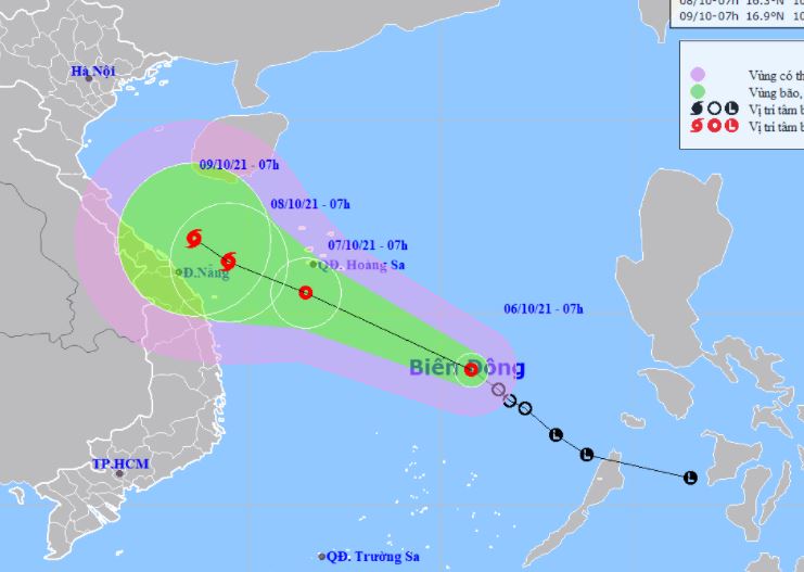
A tropical depression has entered the East Vietnam Sea and is likely to become a storm over the next few days, bringing downpours to central provinces, according to a report by the National Center for Hydro-meteorological Forecasting.
At 7:00 am on Wednesday, the tropical depression was located 270 kilometers northeast of Song Tu Tay Island in Vietnam's Truong Sa (Spratly) archipelago.
The average wind speed was at 40-50km per hour while gusts blew at up to 75km an hour.
The low-pressure system is expected to travel northwest in the next 48 hours and evolve into a storm.
By 7:00 am on Friday, the storm is expected to be 240 kilometers west of Vietnam's Hoang Sa (Paracel) archipelago, with winds at 60-90km per hour and gusts at up to 120km an hour.
|
|
| A map detailing the route of the tropical depression in the East Vietnam Sea from October 6 to 9, 2021. Photo: National Center for Hydro-meteorological Forecasting |
From October 6 to 8, downpours will lash the localities between north-central Quang Binh Province and south-central Phu Yen Province, as well as some provinces in the Central Highlands.
The average rainfall will be 300-500 millimeters from Quang Binh to Quang Ngai, and 100-300 millimeters from Binh Dinh to Phu Yen.
Torrential rains are forecast to dampen other north-central provinces and the Red River Delta from October 9 to 12.
The weather pattern will pose high risk of flash floods and landslides in mountainous areas and inundation in low-lying areas.
Like us on Facebook or follow us on Twitter to get the latest news about Vietnam!

The rainy season will commence in southern Vietnam somewhere between May 10 and 15

During last week alone, eight clusters with 195 patients were documented in Hanoi, the HCDC reported, warning that the city is entering a peak of the HFMD epidemic
3 days ago
An electrical motor incident happened on a stone crushing line at the plant
2 days ago
The city is taking measures to adapt to droughts and saline intrusion during the dry season
2 days ago
Good morning from Vietnam!
1 day ago
The rainy season will commence in southern Vietnam somewhere between May 10 and 15
2 days ago
TikTok Shop’s turnover increased 15.5 percent over the last quarter of 2023


He drew the virus, vaccine, and earth on the exterior walls of a house

TikTok Shop’s turnover increased 15.5 percent over the last quarter of 2023

The firm intends to invest VND630-650 billion (US$24.8-25.6 million) in purchasing 700 hybrid cars

The hailstorm in Van Ho District, Son La Province lasted about one hour

Japan, the world's fifth-largest emitter of greenhouse gases, covers a surface area smaller than California but has some of the longest coastlines in the world

Cities with the poorest quality air are concentrated in the West

All short-selling transactions by institutional investors will be electronically processed and then filtered through a central detection system

The walking space surrounding the iconic Ho Guom will be open for six consecutive days

The situation is putting the region’s crops at risk

Good morning from Vietnam!

This is not the first time that Minister Son has invited a foreign counterpart to have breakfast and take a stroll in the Vietnamese capital