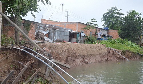
Authorities have identified the major causes behind serious subsidence in one Mekong Delta province, citing excessive sand exploitation as the primary ‘culprit.’
A working delegation, led by the Ministry of Agriculture and Rural Development, on Thursday morning assessed widespread riverbank collapse in Dong Thap Province.
In a meeting with the provincial People’s Committee that same day, the Dong Thap Department of Agriculture and Rural Development reported that 45 sites across the province are dealing with the affects of subsidence.
Four separate areas in the locality have been hit with subsidence since the beginning of April, with the total area of subsided land topping 3,250 square meters.
If the subsidence continues, the section of National Highway 30 passing through Dong Thap could be affected, the agriculture department warned.
An emergency alert was also issued in response to a riverbank collapse along the Tien (Front) River in Binh Thanh Commune, Thanh Binh District, where a 36.8 meter deep vortex was spotted nearly 80 meters off shore.
Working with the provincial administration, the delegation presented their findings on the causes of the increasingly severe subsidence, naming excessive sand exploitation as a primary factor.
According to Do Hoai Nam, an official from the Institute of Coastal and Offshore Engineering, the Tien River became one to 1.8 meters deeper between 1998 and 2008.
The Tien River and Hau (Back) River are two of the most major waterways in the Mekong Delta.
The Dong Thap People’s Committee requested that the central government provide VND82 billion (US$3.59 million) to help relocate residents in affected areas throughout the province.
The local administration previously stated that subsidence was threatening 227 households along a 2.3 kilometer section of the Tien River.


