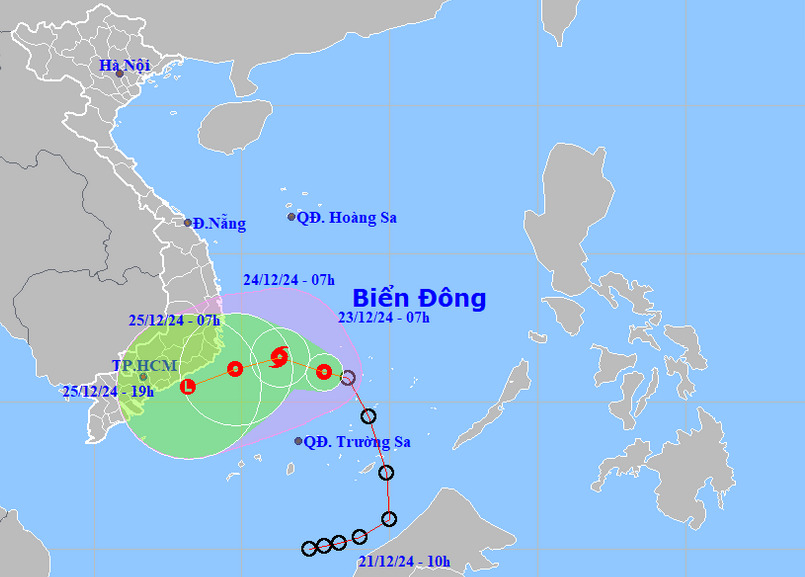
A tropical depression in the East Vietnam Sea is expected to intensify into the 10th storm to hit Vietnam this year, according to the National Center for Hydro-Meteorological Forecasting.
At 7:00 am on Monday, the tropical depression was located in the northwest of Vietnam’s Truong Sa (Spratly) archipelago in the East Vietnam Sea, packing maximum sustained winds of 61kph near its center.
It was moving west-northwest at a speed of 10kph.
Over the next 24 hours, the storm is projected to maintain speed and direction and strengthen into a storm.
By 7:00 am on Tuesday, the storm is expected to be in the southwestern part of the central East Vietnam Sea, with winds strengthening to 74kph and gusts up to level 10.
Over the next two days, it is predicted the storm will shift west-southwest at 5-10kph and gradually weaken into a tropical depression.
By 7:00 am on Wednesday, the storm could be spotted in the waters from south-central Phu Yen Province to southern Ba Ria-Vung Tau Province.
For the next three days, the tropical depression will possibly travel west-southwest at approximate speeds of 10kph, continuing to weaken.
The national weather agency warned that parts of the East Vietnam Sea may experience strong winds, high waves of 4-6m, and rough seas due to this progression.
Ships operating in affected areas are at risk due to severe thunderstorms, squalls, strong winds, and high waves.
Between Monday and Wednesday, moderate to heavy rainfall could hit several parts of the country because of the combined effects of the storm and a cold front.
In central Vietnam, the provinces and cities from Da Nang to Khanh Hoa may see widespread rainfall of 30-80mm, with localized amounts exceeding 200mm in some areas.
Residents in the south-central and Central Highlands regions are expected to see rain totals of 30-80mm from Tuesday to Wednesday, with some areas exceeding 150mm.
In the southeastern region, they may experience scattered showers and thunderstorms between Tuesday night and Wednesday.
Heavy rainfall may cause flooding in low-lying, urban areas, landslides in hilly regions, plus flash floods in rivers and small streams.
Like us on Facebook or follow us on X to get the latest news about Vietnam!


