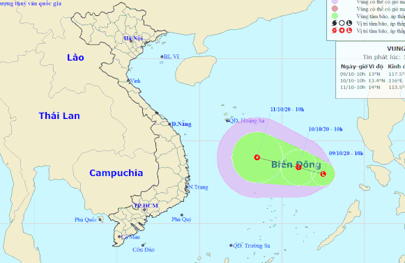
A new low-pressure area has formed in the East Vietnam Sea and is forecast to strengthen into a tropical depression as it heads toward central provinces.
As of 10:00 am on Friday, the low-pressure zone was located about 400 kilometers northeast of Song Tu Tay Island in Vietnam's Truong Sa (Spratly) archipelago, according to the National Center for Hydro-meteorological Forecasting.
In the next 24 hours, it will travel northwest at a velocity of 10km per hour and potentially develop into a tropical depression.
The tropical depression will be at 250 kilometers northeast of Song Tu Tay Island by 10:00 am on Saturday, with winds at 40 to 60km per hour and gusts at up to 90km an hour.
It is expected to continue heading northwest in the next 24 to 48 hours and pick up strength.
Medium to heavy rain dampened localities from north-central Ha Tinh Province to south-central Binh Dinh Province on Thursday.
The highest rainfall was recorded at 330 millimeters in north-central Quang Tri Province, followed by 315 millimeters in central Thua Thien-Hue Province.
Under the influence of a tropical convergence zone and cold front, heavy downpours are forecast to continue battering localities between Ha Tinh Province and central Quang Ngai Province on Saturday.
Average rainfall will be at 100 to 250 millimeters and over 300 millimeters in some areas.
Torrential rain is expected to lash central and south-central provinces from October 11 to 13.
Like us on Facebook or follow us on Twitter to get the latest news about Vietnam!


