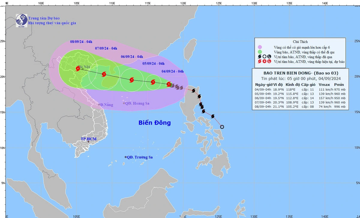
Typhoon Yagi, the third storm to strike the East Vietnam Sea this year, could reach super typhoon status on Thursday with sustained winds of up to 201 kph as it heads toward China’s Leizhou Peninsula and Hainan Island, according to the National Center for Hydrometeorological Forecasting.
Yagi was located about 550 km east of China’s Hainan at 4:00 am on Thursday with winds of up to 183 kph and gusts reaching over 220 kph.
The central weather agency reported that the typhoon was moving west-northwest toward Hainan-Leizhou at a speed of 10-15 kph and will likely upgrade into a super typhoon with sustained winds of 184-201 kph.
By 4:00 am on Friday, the super typhoon is forecast to be within 210 kilometers of Hainan with winds reaching 201 kph and squalls of up to 220 kph.
Over the following 24-48 hours, the storm is expected to continue moving northwest at 10 kph toward the southern part of Leizhou before entering the Gulf of Tonkin.
After passing Leizhou, Yagi will hit mainland China where its strength will decrease.
By 4:00 am on Saturday, Yagi’s will be centered in the northeast region of the Gulf of Tonkin with winds of up to 166 kph and gusts reaching 220 kph.
It will then continue moving west-northwest at 15 kph toward northern Vietnam before making landfall in the region between Quang Ninh and Ninh Binh Provinces on Saturday.
Yagi will continue on a northwestern trajectory before downgrading into a tropical depression and then a low-pressure system.
During the typhoon, the northern part of the East Vietnam Sea will see extremely rough waves of four to six meters high with powerful winds ranging from 150 kph to 201 kph, along with gusts reaching over 220 kph over the next 24 hours.
On Friday night, the Gulf of Tonkin will see rough seas and strong winds ranging from 89 kph to 166 kph with gusts blowing 220 kph, posing significant risks to vessels.
Over the next 24 hours, the northern area of the East Vietnam Sea will be extremely rough, with waves measuring seven to nine meters, even to 10-12 meters in the waters near Yagi’s eye.
From Friday through Monday, heavy rains will hit the northern and north-central regions with precipitation of 100-300mm, even up to 500mm in some localities.
Heavy rains from storm Yagi could trigger flooding in low-lying and urban areas, potentially leading to rivers overflowing and landslides in hilly and mountainous regions, the center warned.
At a meeting on Thursday, Minister of Agriculture and Rural Development Le Minh Hoan requested that all coastal localities in northern and north-central regions take effective measures to cope with the coming typhoon.
Efforts should be made to minimize risks to life, property, industrial park infrastructure, telecommunications, electricity, river dykes, and other construction works, the minister asked.
Local authorities should evacuate people, especially tourists, from dangerous areas to safe places if necessary.
Depending on the situation, local governments may ban activities involving large numbers of people, Hoan said.
In an urgent directive on Tuesday, Prime Minister Pham Minh Chinh ordered the ministries, agencies, and local authorities from Quang Ngai to Quang Ninh Provinces, as well as in the northern region, to take immediate measures to respond to the approaching typhoon.
Like us on Facebook or follow us on Twitter to get the latest news about Vietnam!


