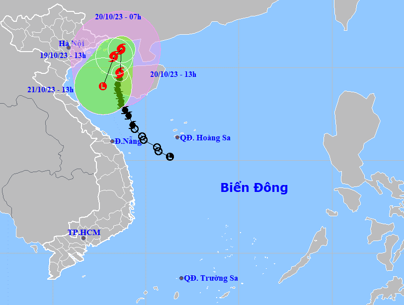
Storm No. 5, which upgraded from a tropical depression in the East Vietnam Sea on Wednesday, is moving northward and will likely turn south-west on Friday after meeting a cold front, according to the national weather forecast center.
The storm was spotted in the eastern waters of the Gulf of Tonkin, packing winds blowing at 74 kilometers per hour at 1:00 pm on Thursday.
It is forecast to travel northward before turning south-west at some 5-10 kilometers over the next 24 hours, said the National Center for Hydro-Meteorological Forecasting.
The system, which may be spotted in the Gulf of Tonkin by 1:00 pm on Friday, was believed to keep the south-southwest direction before weakening to a tropical depression and then a low pressure area in the Gulf of Tonkin on Saturday.
The storm has caused rough seas and increased strong winds in the Gulf of Tonkin area, including Co To Island off Quang Ninh Province and Bach Long Vi Island off Hai Phong City, both in northern Vietnam.
All fishing vessels, wharfs, aquaculture farming areas, and dykes in these areas could be impacted by strong winds and high waves.
Powerful winds will likely hit the coastal areas running from Quang Ninh to Hai Phong from early Friday morning.
Moderate to heavy rains are forecast in coastal areas in the Red River Delta between Thursday night and Saturday morning.
The national weather center added that a cold spell was approaching northern Vietnam on Thursday, making temperatures in many parts of the region falling further especially at night and in the morning starting from Friday.
People in northern and north-central localities will see temperatures drop to 19-22 degrees Celsius and even below 15 degrees in mountainous locations.
Like us on Facebook or follow us on Twitter to get the latest news about Vietnam!


