Last week’s earthquake in My Duc District, Hanoi underscores the possibility of additional strong earthquakes in the Vietnamese capital if the Red River fault zone becomes active, as per an expert’s analysis.
Seismologists attribute the magnitude-4 earthquake in outlying My Duc District on March 25 to the Red River fault zone, according to Assoc. Prof. Dr. Nguyen Hong Phuong, chairman of the Scientific Council at the Institute of Geophysics under the Vietnam Academy of Science and Technology.
The quake is categorized as a minor, natural earthquake.
Its epicenter was approximately 1.8km from the Red River fault boundary, with a depth of about 16km, aligning well with models of tremor generation at the fault.
In an interview with Tuoi Tre (Youth) newspaper, Phuong disclosed insights into the hazards posed by the Red River fault zone.
What lessons can we draw from the earthquake in My Duc District?
There are indications that Hanoi remains susceptible to earthquakes, especially if the Red River fault zone becomes active, potentially triggering a significant seismic event.
It is imperative to prepare for future earthquakes along this fault line, particularly in densely populated urban areas like Hanoi, home to over 10 million people and numerous high-rise buildings.
The impact of a strong earthquake here could be devastating.
For instance, despite being of equal intensity, the Kobe earthquake in Japan in 1995 claimed 6,000 lives, while the quake in Tuan Giao Town, located in Dien Bien Province, northern Vietnam, in 1983 resulted in no casualties.
The disparity in fatalities can be attributed to the urban setting of Kobe, contrasting with the uninhabited area where Tuan Giao is situated.
What is the level of danger posed by the Red River fault zone and how probable is it for earthquakes to occur in Hanoi?
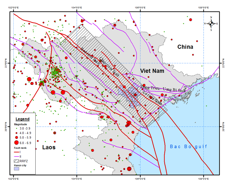
The Red River fault zone, originating from Yunnan, China, extends in a northwest-southeast direction, reaching Tam Dao Town in the northern Vietnamese province of Vinh Phuc.
From Vinh Phuc downward, the fault zone is obscured by sediment layers and appears discontinuous, yet scientists speculate its continuation to the Vietnamese coast and the Gulf of Tonkin.
The fault zone comprises several major faults, including the Red River fault, Lo River fault, and Chay River fault, which are prominently visible in the Hanoi area. These faults run parallel to each other in a northwest-southeast direction.
Clarence Allen (1925-2021), an American geologist collaborating with Chinese counterparts, identified ongoing movements along the Red River fault zone from the beginning of the Holocene Epoch (11,700 years ago – present day), estimating its displacement to be approximately 3 to 5mm per year.
This suggests that the fault zone remains active and capable of generating earthquakes.
However, the intensity of activity varies across different segments of the fault zone.
While the northern part in Chinese territory has experienced earthquakes with magnitudes of up to seven, the section adjacent to the Vietnamese border exhibits fewer signs of seismic activity, with sporadic and relatively minor earthquakes recorded thus far.
In Vietnam, the Institute of Geophysics has documented approximately 30 earthquakes along the Red River fault zone, predominantly characterized as small to moderate tremors.
However, as the fault zone traverses through Hanoi, the capital city is situated directly atop its source area, rendering it vulnerable to potential seismic events that could inflict damage upon the urban community.
|
|
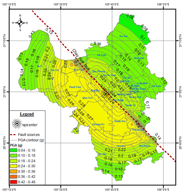
| A Peak Ground Acceleration (PGA) map shows the level of ground shaking expected from earthquakes along the Chay River fault. Photo: Nguyen Hong Phuong |
The pressing inquiry on many minds is: Could an earthquake strike Hanoi?
Compared to fault zones of similar length worldwide, the Red River fault zone is deemed relatively weak in its earthquake-generating capacity, with no recorded instances of significant damage in Vietnamese territory.
However, it remains a seismic risk, prompting ongoing evaluation and predictive modeling by seismologists to assess potential damage to infrastructure and populations.
Among its segments, the Chay River fault is identified as capable of producing the strongest earthquakes, while the Red River and Lo River faults are expected to yield weaker tremors.
Seismic scenarios based on these fault zones have been developed for five urban districts in Hanoi to gauge seismic risks and anticipate potential impacts on communities and structures.
Which areas in Hanoi are most vulnerable to earthquake impacts?
We assess how earthquakes affect both buildings and individuals, taking into account various factors such as earthquake magnitudes, including levels 5, 6, and 7. Level-7 earthquakes are recognized for causing the most substantial damage.
Throughout Hanoi, we have developed a ground classification map, categorizing areas into types A, B, C, D, and E, with A representing the most robust ground and E the weakest.
For instance, in Soc Son District, the predominant ground type is A, while in central Hanoi, it is primarily type D.
Areas like riverbanks and mudflats are classified as type E.
During earthquakes, damage tends to be more severe in type-E ground areas compared to type-A ground areas.
|
|
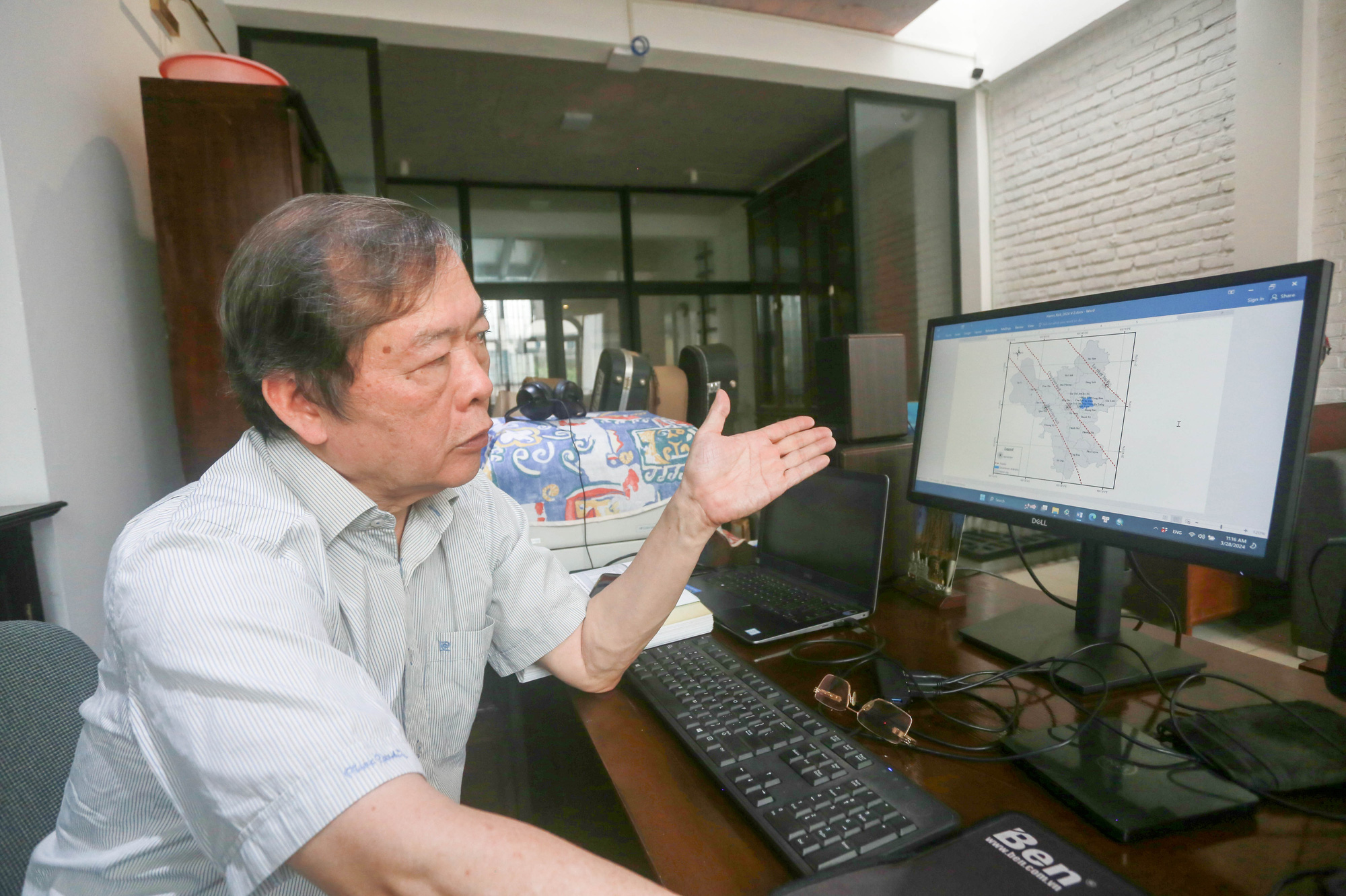
| Assoc. Prof. Dr. Nguyen Hong Phuong, chairman of the Scientific Council at the Institute of Geophysics under the Vietnam Academy of Science and Technology |
You and your colleagues previously cautioned that Hanoi might experience a powerful earthquake reaching level 8 (approximately 6.3-6.5 on the Richter scale). Have the recent forecasts altered this prediction?
Currently, forecasts suggest that Hanoi may face an earthquake reaching level 8, but our research has provided more nuanced insights.
Instead of a blanket level-8 earthquake warning for the entire city, we now have more detailed seismic risk assessments for each district.
Urban districts exhibit the highest ground vibrations, reaching level 8, with return periods of 475 and 975 years.
In addition, areas such as Cau Giay, Thanh Xuan, and Ha Dong Districts, along with parts of Ba Dinh, Dong Da, and Hoang Mai Districts, experience the strongest ground vibrations at return periods of 2,475 and 9,975 years.
Given the significant earthquake risks, what recommendations do you propose for residents and local authorities?
Given Hanoi’s location in a level-8 seismic zone, the likelihood of earthquake-related damage is considerable.
It is imperative for both individuals and government bodies to recognize the inevitability of earthquakes along the Red River fault zone.
In the absence of preparedness measures, earthquakes can result in significant devastation.
Adherence to seismic design standards and regulations is crucial during construction endeavors, whether for residential homes or high-rises.
Moreover, urban planners, construction engineers, and relevant authorities must ensure compliance with seismic guidelines.
Regular updates to seismic design standards in construction projects and the formulation of earthquake response strategies are essential components of disaster preparedness efforts.
Like us on Facebook or follow us on Twitter to get the latest news about Vietnam!


