Typhoon Yagi gets stronger, moves toward China’s Hainan Island before entering Gulf of Tokin
Wednesday, September 04, 2024, 09:34 GMT+7

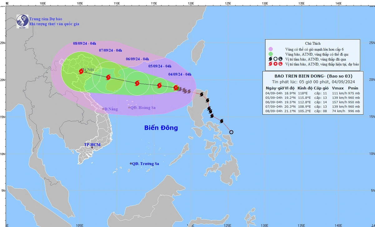
Typhoon Yagi, the third storm to strike the East Vietnam Sea this year, has intensified, with gusts reaching up to 149 kph, and is expected to approach China's Hainan Island before entering the Gulf of Tonkin by Saturday, according to the National Center for Hydrometeorological Forecasting.
As of 4:00 am on Wednesday, the storm was located in the northern region of the East Vietnam Sea, east of Hainan Island, with sustained winds of up to 117 kph and gusts reaching 149 kph.
The central weather agency reported that Yagi is moving westward toward Hainan Island at a speed of 10 kph, and its strength is anticipated to increase.
By 4:00 am on Thursday, the typhoon is forecast to be about 560 kilometers east of Hainan, with winds of 149 kph and squalls up to 201 kph.
Over the following 24-48 hours, the storm is expected to continue its westward trajectory at 10 kph, gaining further intensity.
By 4:00 am on Friday, the storm’s center is projected to be 230 kilometers east of Hainan, with winds of 166 kph and squalls up to 220 kph.
The typhoon is then forecast to move west-northwest, making landfall on Hainan Island before entering the Gulf of Tonkin, where it is likely to weaken slightly.
As of 4:00 am on Saturday, Yagi is expected to be centered in the Gulf of Tonkin, with sustained winds of 149 kph and gusts up to 201 kph.
The storm is predicted to continue moving west-northwest at 15 kph over the next 72 hours, gradually weakening.
Affected by the typhoon, the eastern waters of the northern part of the East Vietnam Sea will be extremely rough with sea waves rising to four to six meters, with powerful winds ranging from 102 kph to 149 kph, along with gusts reaching 201 kph within 24 hours from now.
On Thursday and Friday, squalls near typhoon Yagi's eye could intensify to 220 kph, causing dangerously rough seas with waves potentially reaching up to nine meters, posing significant risks to vessels.
In a telegram issued on Monday, the Ministry of Agriculture and Rural Development instructed coastal provinces and relevant agencies to closely monitor Yagi.
Authorities were urged to keep ships operating in potentially affected sea areas informed of the storm's developments to avoid impacts and to prepare rescue plans if necessary.
Prime Minister Pham Minh Chinh also issued an urgent directive on Tuesday, ordering the ministries, agencies, and local authorities from Quang Ngai to Quang Ninh Provinces, as well as in the northern region, to take immediate measures to respond to the approaching typhoon, which could directly impact the country in the coming days.
Like us on Facebook or follow us on X to get the latest news about Vietnam!

Nuclear technology, including power generation and medical applications, is vital for Vietnam’s development

The group of 50 people attacked and injured five pagoda visitors
13 hours ago
The dog bit him on his thumb, causing a bleeding wound
1 day ago
The metro is proving to be incredibly attractive
1 day ago
Many people criticized the restaurant for damaging Nha Trang's tourism reputation
9 hours ago
Good morning from Vietnam!
18 hours ago Nuclear technology, including power generation and medical applications, is vital for Vietnam’s development


Nuclear technology, including power generation and medical applications, is vital for Vietnam’s development

Major construction projects are underway along both banks of the iconic river

Salvage crews have recovered the bodies of all 67 people killed when a passenger plane and a US Army helicopter collided near Washington and plunged into the Potomac River, officials said Tuesday

Holding long-term global warming to two degrees Celsius -- the fallback target of the Paris climate accord -- is now 'impossible,' according to a stark new analysis published by leading scientists

Morocco's surprise run to the 2022 World Cup semi-finals sparked hopes that such a moment is not far off

Both leaders agreed to further enhance political trust and accelerate the implementation of high-level agreements

Generative artificial intelligence (AI) has blossomed around large US companies, with a few European and Chinese rivals

Some other international couriers including FedEx and SF Express, China's largest express delivery company, said they continue to send packages to the U.S.
Many people criticized the restaurant for damaging Nha Trang's tourism reputation

The patient had a history of high blood pressure but had been inconsistent in taking his medication


