How the Turkey earthquake tore a 300-kilometre rupture in the Earth's surface
Saturday, February 18, 2023, 13:54 GMT+7

The ground in Turkey and northern Syria was torn, cracked open, and dragged in different directions after the massive 7.8 magnitude quake and its aftershocks on Feb. 6.
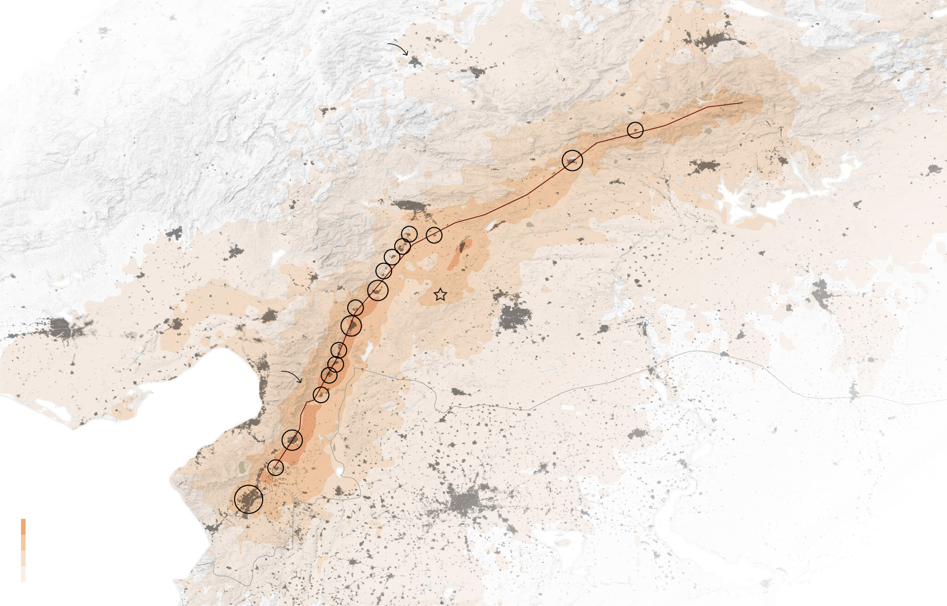
The map below illustrates how far the surface moved during the quake. Two clear ruptures now stretch for hundreds of kilometres where the land moved up to 7 metres (23 feet) in opposite directions.
Even at the southern tip of the larger rupture, about 150 km from the epicentre of the initial 7.8 magnitude quake, the village of Tepehan, in Hatay province, witnessed extraordinary cracks tearing through the surface.
Drone footage filmed on Feb. 10 showed fissures slicing across an olive grove in the village.
"At around 4:20 a.m. (0120GMT) at night, we woke up to a noise. With the initial panic, nobody knew whether we could leave home or whether we could survive. We lost hope," said local resident Mehmet Temizkan.
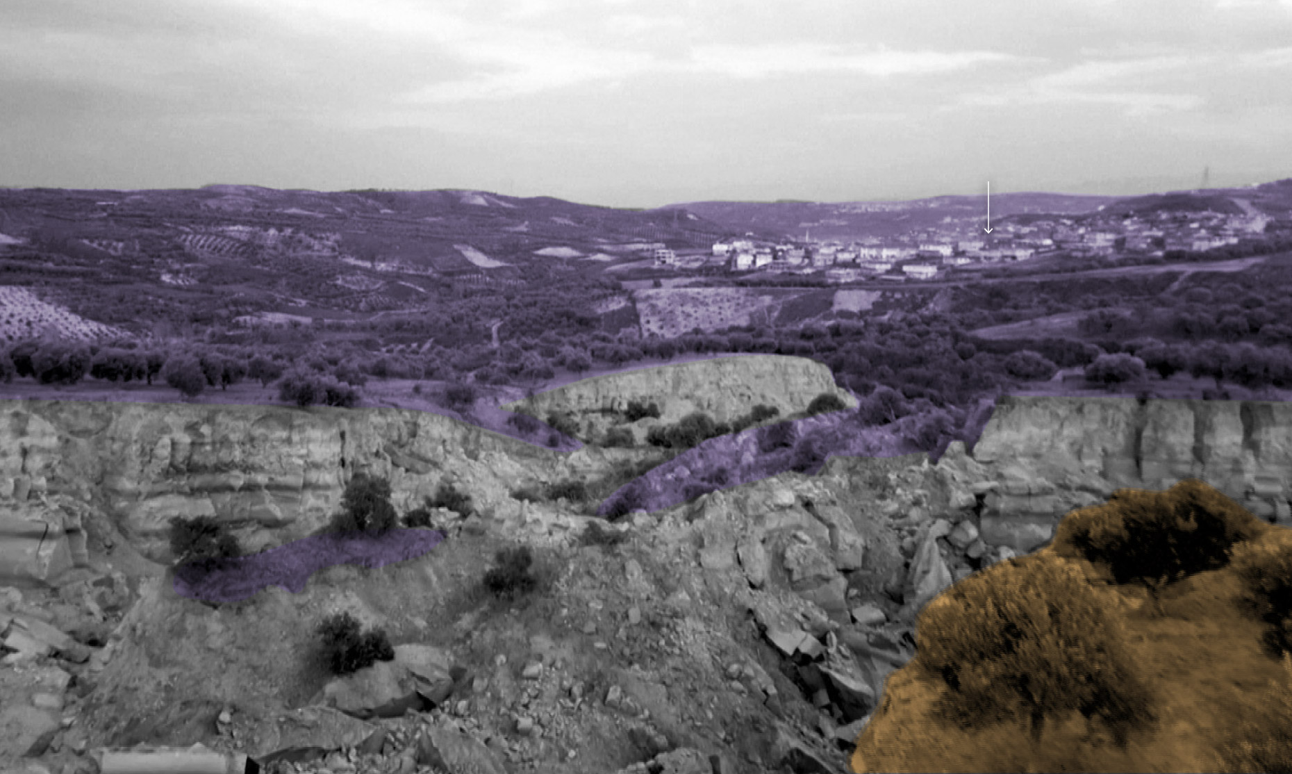 |
| Drone footage filmed on Feb. 10 showed fissures slicing across an olive grove in the village of Tepehan, in Hatay province, Turkey. Photo: Reuters |
“These were very large and powerful earthquakes that ruptured all the way up to the surface over a long series of fault segments,” Eric Fielding, a geophysicist at NASA’s Jet Propulsion Laboratory, said in a statement on the agency’s Earth Observatory website.
“This generated extremely strong shaking over a very large area that hit many cities and towns full of people,” he said. “The rupture length and magnitude of the magnitude 7.8 earthquake was similar to the 1906 earthquake that destroyed San Francisco.”
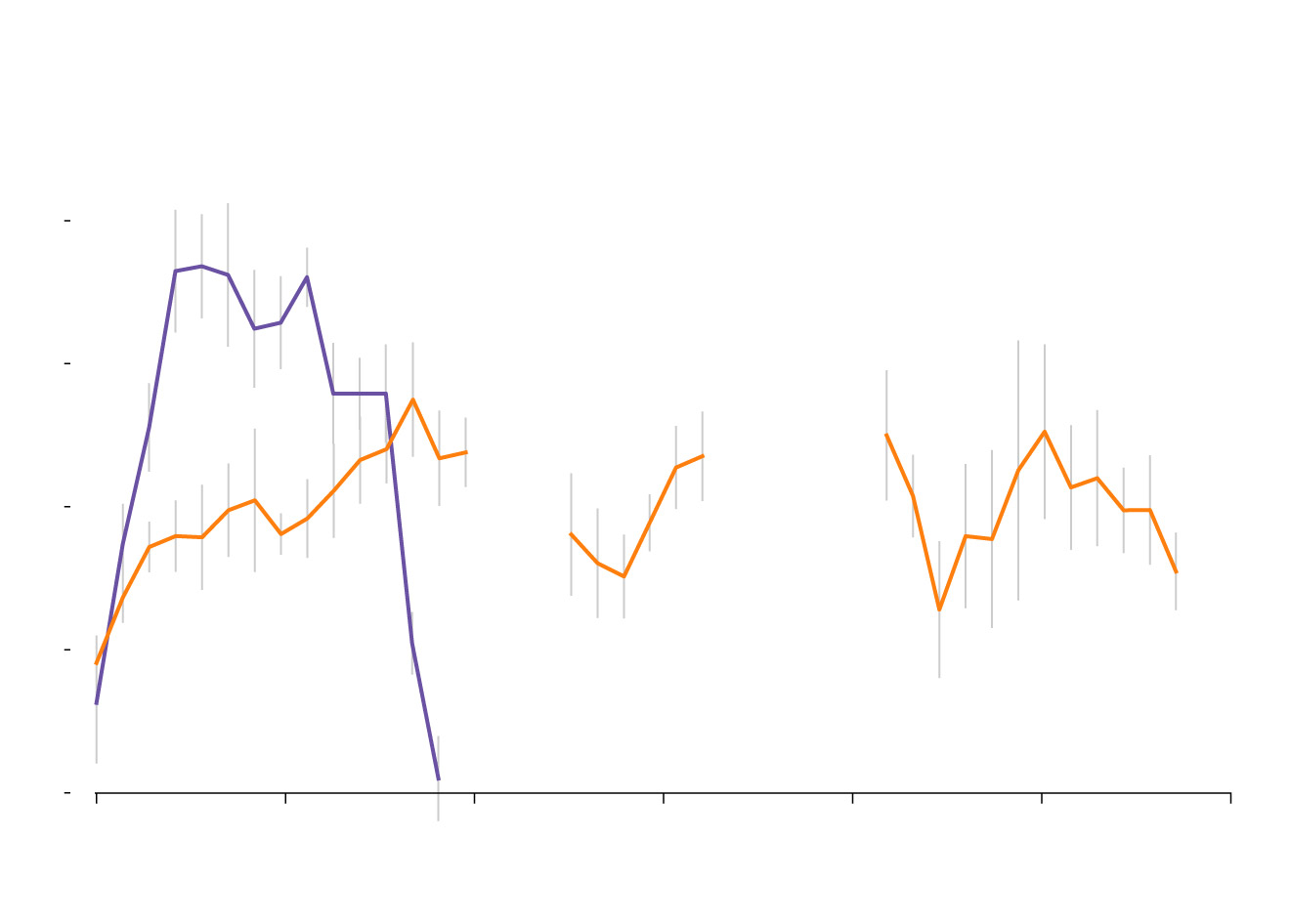
Land on either side of the ruptures moved in opposite directions, settling up to 7 metres from its starting point in some locations, according to data provided by Chris Milliner of the California Institute of Technology.
The main quake had a long rupture with displacements of up to 7m. The shorter rupture from the 7.5 aftershock saw land displaced up to 5m in places.
 |
| Ruptures from the two quakes. Photo: Reuters |
Joining the dots
The smaller towns directly above the fault line suffered some of the most severe shaking. The main rupture tore straight through many of these settlements as if it were joining the dots on a map.
Susan Hough, a seismologist at the United States Geological Survey, said that in many cases, people end up living next to fault zones for resource reasons.
“If you are living along the base of the mountains, there may be more water there,” Hough said.
Many of the towns lie at the foot of a mountain range to the East.
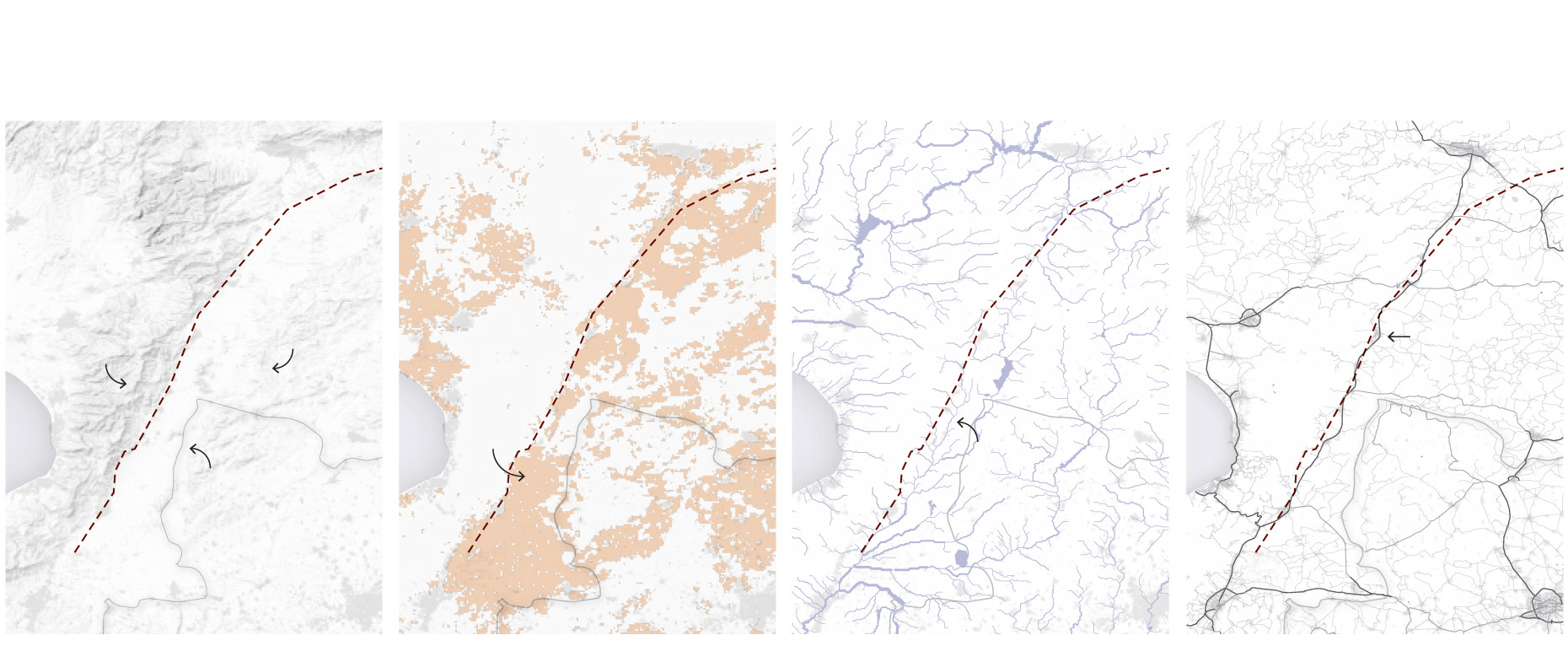 |
| Possible reasons for human settlement along the fault. Photo: Reuters |
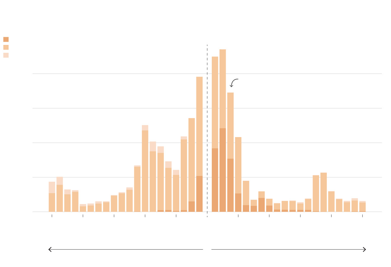
A Reuters analysis of population estimates shows that the settlements built near the fault zone tended to have higher populations the closer they were to the rupture. Many of the fatalities and building collapses happened in larger cities distant from the fault zone, however, which experts said related to the underlying geography.
Margarita Segou, a seismologist with the British Geological Survey, said it is safer to build on mountainous rock than the soft soil of the plains, which tends to amplify ground motion.
 |
| People living near the rupture. Photo: Reuters |
Towns torn apart
Satellite images clearly showed the surface displacement. The pinpoint accuracy of the images allows the movement of land to be traced.
Images from Planet Labs show a surface rupture running straight through the middle of a village near Nurdagi, Turkey, with the ground clearly moving a few metres on either side.
Another image shows a long crack and surface movement near the neighbouring village of Tevekkeli, which sits on the fault line south of Kahramanmaras. The entire village appears to have moved a few metres and cracks slice through fields and tracks.
 |
| The crack is comparable to the length of Taiwan, South Korea, or Portugal. Photo: Reuters |
The scale of the event
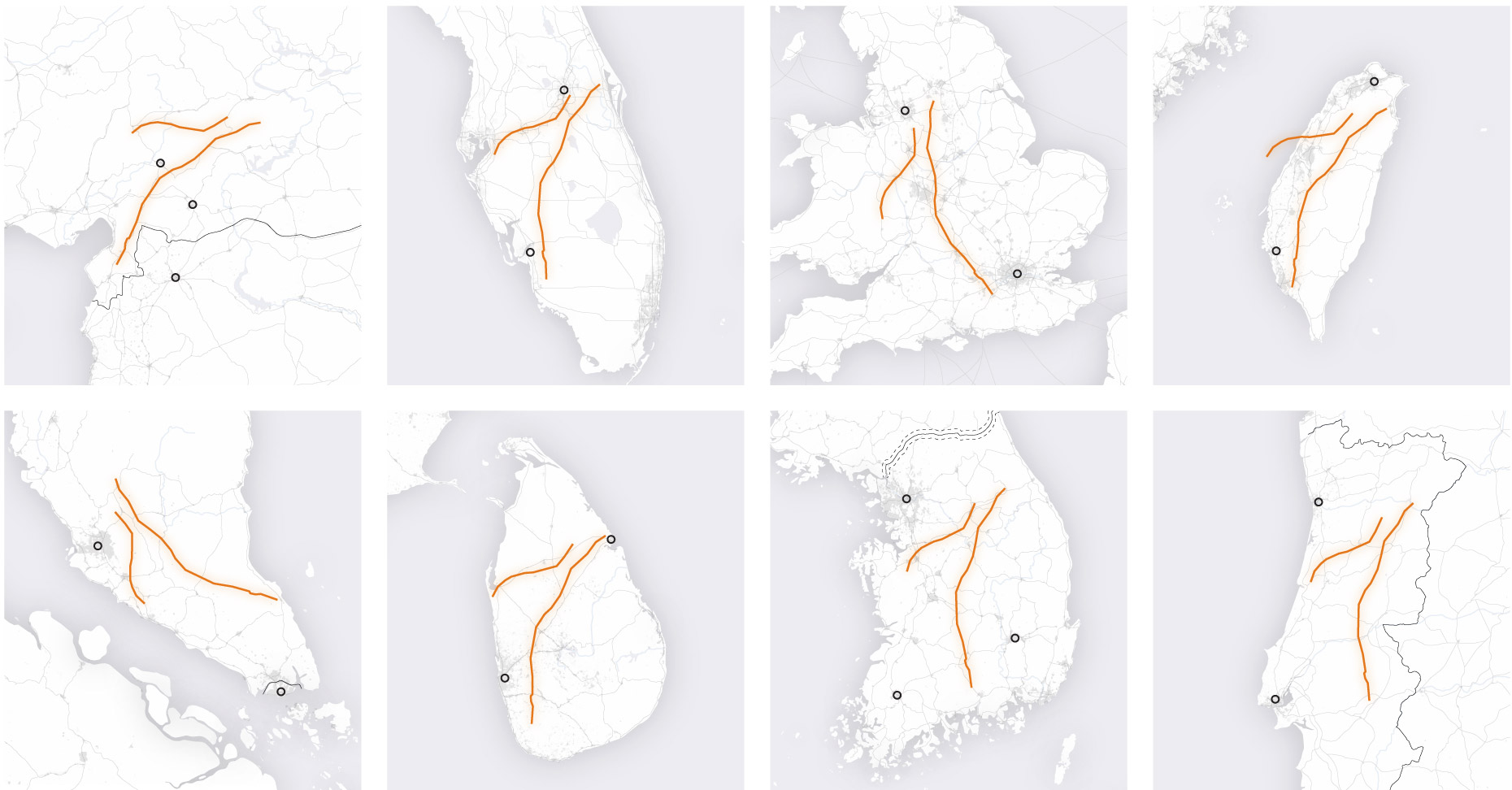
The earthquakes opened two enormous cracks in Earth's surface, the longer of which stretches about 300km across southern Turkey.
“An earthquake of this size causes the fault to break along quite a long extent,” said Roger Musson, an honorary research associate at the British Geological Survey. The maps below show the size of the ruptures relative to other well-known land masses. The crack is comparable to the length of Taiwan, South Korea, or Portugal.
“To have a fault this long fail in a populated area is horrific,” said Professor Tim Wright, head of the U.K. Centre for the Observation & Modelling of Earthquakes, Volcanoes & Tectonics (COMET).
Experts say the surface ruptures offer a valuable source of data that will help them understand the processes that caused such a devastating event - and ultimately save lives.
“Scientists around the world are using these kinds of data to build ‘source models’ of the event,” Wright said, adding that such models could predict how structures behave during earthquakes and how they might affect key infrastructure such as bridges and roads. “In the longer-term, forensically understanding every earthquake helps us prepare for future events in different regions.”
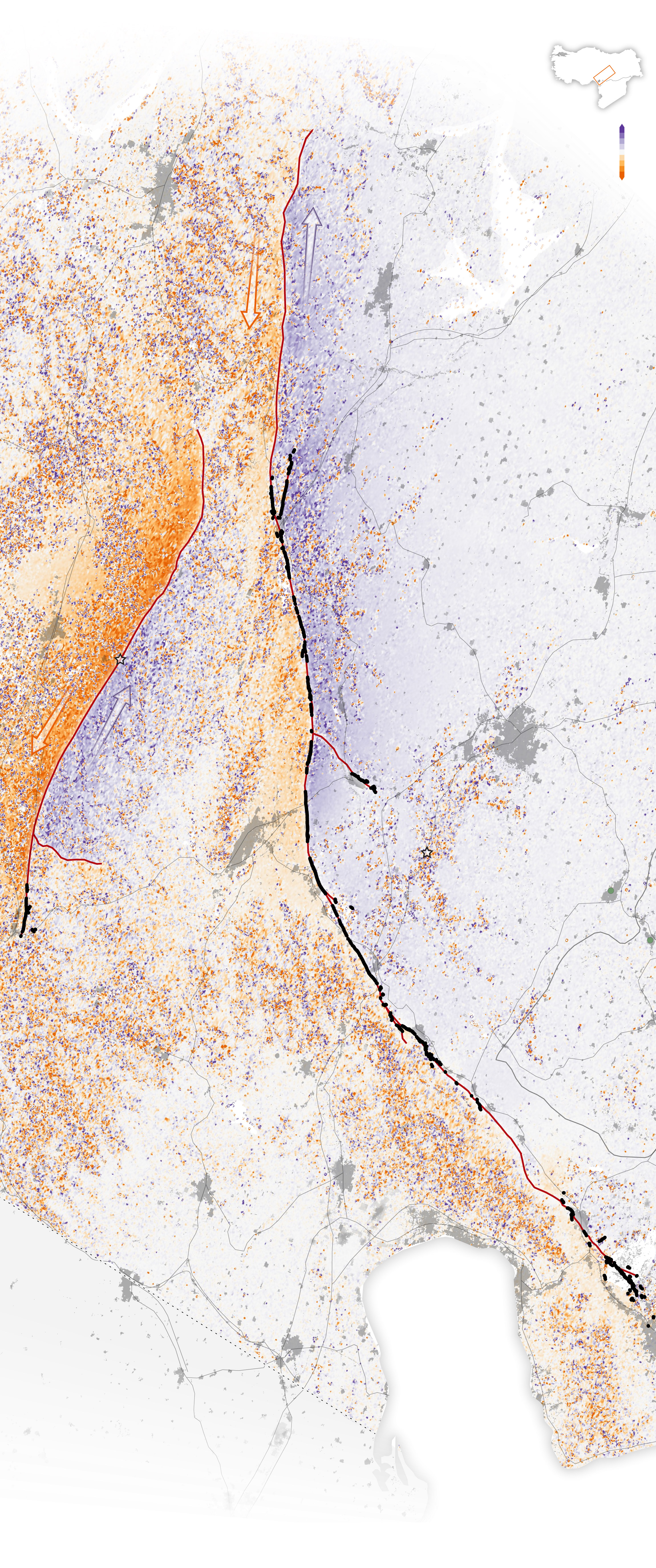 |
| A map illustrates how far the surface moved during the massive 7.8 magnitude quake and its aftershocks that hit Turkey and northern Syria on February 6, 2023. Photo: Reuters |

Indonesia has 123 active projects in Vietnam, with a total registered capital of US$682 million

The export price of first-grade frozen durians is around VND170,000 - VND180,000 (US$6.7 - $7.1) per kilogram

Though the immediate shock has passed, COVID-19's legacy continues to reshape global economies and markets
1 day ago
China's consumer price index in February fell at the sharpest pace in 13 months
1 day ago
Hermes designer Nadege Vanhee presented a fall-winter 2025 collection of glossy coats, dresses and trousers in dark-coloured leather
1 day ago
Surveillance footage released by the city shows the locomotive dragging the young man for several yards (meters)
1 day ago
Kantar's owners Bain Capital and advertising group WPP declined to comment on the reports, while Kantar did not immediately respond to requests for comment
15 hours ago
His family members expected to extend their father’s light to those who are visually impaired


His family members expected to extend their father’s light to those who are visually impaired

The model was trained using 120 of Nvidia’s H100 GPUs and completed in about four weeks

Rumors that the T3 terminal would officially open on May 5 have sparked public interest

Former central banker Mark Carney will succeed Justin Trudeau as prime minister

Palm oil makes up more than half of global vegetable oil shipments

Many Vietnamese viewers strongly protested when they saw the clip displaying the illicit ‘nine-dash line' during the contest’s final round on Sunday

The event marked the 70th anniversary of Vietnam-Indonesia diplomatic ties

Torrential rain from the remnants of Cyclone Alfred flooded swathes of Australia's east coast on Monday, as workers battled to restore power to more than 190,000 homes and businesses

Argentina announced three days of national mourning late Sunday after authorities raised the death toll from recent flash flooding to 16, with more still missing

The value of art sold in 2024 slumped to $9.9 billion (9.1 billion euros), the lowest level since 2009


