Storm Podul to bring downpours to northern, north-central Vietnam ahead of National Day
Wednesday, August 28, 2019, 12:01 GMT+7

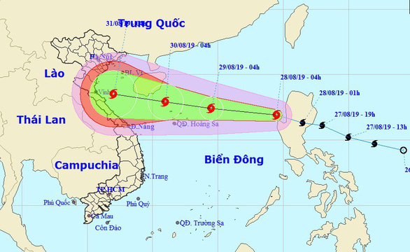
This year’s fourth tropical storm has entered the East Vietnam Sea and is forecast to make landfall in north-central provinces later this week.
According to the National Center for Hydro-meteorological Forecasting, Tropical Storm Podul was located about 620 kilometers east of Vietnam's Hoang Sa (Paracel) archipelago as of 7:00 am on Wednesday.
Average wind speed was recorded at 60 to 75km per hour, with gusts at up to 100km an hour.
The storm will travel westward in the next 24 hours as it picks up strength and is expected to hit Hoang Sa on Thursday morning, unleashing winds blowing at between 60 and 90km per hour.
As of 7:00 am on Friday, Podul will be located south of China’s Hainan Island, with winds increasing to between 75 and 100km an hour.
It is expected to make landfall on the coastline between Thanh Hoa and Quang Binh Provinces in north-central Vietnam later the same day, before weakening into a tropical depression.
Under the influence of the storm and its circulation, rough seas and strong waves will occur along the coast in northern and central provinces.
Heavy rains will dampen northern and north-central Vietnam from August 31 to September 2 and are likely to affect the holiday marking the country’s National Day (September 2).
Rain of milder intensity is in the forecast in the localities between the central city of Da Nang and the south-central province of Binh Thuan during this period.
In the Central Highlands and southern provinces, it will rain mainly in the evening.
Like us on Facebook or follow us on Twitter to get the latest news about Vietnam!

Her daughter, who had just returned from overseas education, mistakenly threw a bag containing several diamond rings

While national average temperatures will largely align with historical norms, northern and central regions are forecast to be 0.5-1 degree Celsius below seasonal averages
2 days ago
This price was 10 times the normal rate of VND40,000 ($1.6) per bowl at the shop, located at 54 Bach Mai Street
2 days ago
Both locals and tourists took advantage of the last day of Tet to stroll, snap photos, and soak in the festive atmosphere
1 day ago
The driver had no driver’s license
1 day ago
The eatery showed invoices saying that it purchased Japanese scallops at VND920,000 ($37) per kilogram
2 days ago
The percentage of Japanese businesses expecting profits in the Vietnamese market has exceeded 64 percent


The percentage of Japanese businesses expecting profits in the Vietnamese market has exceeded 64 percent

Thailand's PTT Exploration and Production said on Tuesday it was looking at BP's assets in Vietnam but had not appointed financial advisers for any plan to bid for them

The affected customer accepted the apology and the refunded amount but chose to donate the money to the poor

The Institute of Geophysics continues to monitor seismic activities in the region to provide timely information and ensure public safety

A possible trade war entailing tariffs is expected to smooth the path for Vietnam to boost its production and exports to replace China to tap the U.S. market

The World Health Organization's chief hit back Monday at US President Donald Trump's reasons for pulling the United States out of the WHO -- and again urged Washington to reconsider

Apple on Monday criticized a pornography app newly available on iPhones in the European Union, saying the bloc's digital policy was undermining consumer confidence in Apple

The fire victims say they have no clarity on what their housing situation is going to be

In the 2023 fiscal year, USAID managed more than $40 billion in combined appropriations

Tremors have been recorded between the volcanic islands of Santorini and Amorgos in the Aegean Sea since Friday


