Storm Koguma downgraded to tropical depression after hitting northern Vietnam
Sunday, June 13, 2021, 11:01 GMT+7

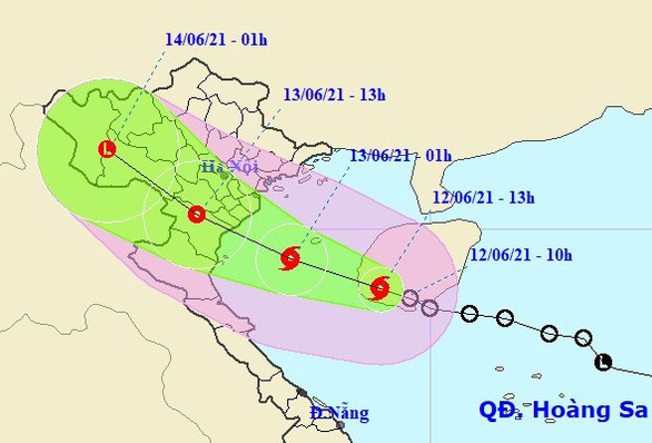
Tropical storm Koguma weakened into a tropical depression on Sunday morning, hours after striking Vietnam’s region from the northern province of Thai Binh to north-central Nghe An Province, the national weather agency has reported.
After making landfall at around 3:00 am on Sunday, the storm was located in the north-central province of Thanh Hoa at 7:00 am, with winds of up to 60 kilometers per hour, and began to be downgraded to a tropical depression, the National Center for Hydro-meteorological Forecasting said.
The depression would become weaker and continue moving west before reaching the border with Laos at 1:00 pm on the same day, the agency forecast.
As impacted by Koguma, the area from Thanh Hoa to Quang Binh Provinces suffered downpours with rainfall ranging between 120 and 280 millimeters during 24 hours from 7:00 am Saturday.
The Gulf of Tonkin, including Vietnam’s Bach Long Vi Island, had rough seas with strong winds of up to 88 kilometers per hour and high waves reaching three meters from Sunday morning.
Simultaneously, winds on the mainland reached a speed of 49 kilometers per hour in the northern delta and Thanh Hoa, and up to 88 kilometers in coastal areas.
The center also forecast moderate to heavy rain, with maximum precipitation of 120 millimeters, for the northern delta and the provinces from Thanh Hoa to Ha Tinh on Sunday.
From Sunday afternoon to Monday morning, the northwest region will have torrents with rainfall of up to over 120 millimeters.
Koguma is the second storm to have struck the East Vietnam Sea in the year to date, after Choi-wan, which made landfall in Taiwan on June 4.
It is forecast that up to 14 storms and tropical depressions will appear in this sea area this year, of which five or six will directly affect Vietnam, the center said.
Like us on Facebook or follow us on Twitter to get the latest news about Vietnam!

Her daughter, who had just returned from overseas education, mistakenly threw a bag containing several diamond rings

While national average temperatures will largely align with historical norms, northern and central regions are forecast to be 0.5-1 degree Celsius below seasonal averages
1 day ago
This price was 10 times the normal rate of VND40,000 ($1.6) per bowl at the shop, located at 54 Bach Mai Street
1 day ago
The eatery showed invoices saying that it purchased Japanese scallops at VND920,000 ($37) per kilogram
1 day ago
Both locals and tourists took advantage of the last day of Tet to stroll, snap photos, and soak in the festive atmosphere
18 hours ago
The driver had no driver’s license
14 hours ago
One particularly serious incident occurred in northern Nam Dinh Province on January 30, killing seven people and injuring two others


One particularly serious incident occurred in northern Nam Dinh Province on January 30, killing seven people and injuring two others

Vietnam has set an ambitious goal to have at least 10 billionaires and five of Asia’s most influential entrepreneurs by 2030

Nguyen Hue Flower Street opened for seven days
The driver had no driver’s license

In early 2022, the Vietnamese government issued a decree granting a three-year exemption from registration fees for electric vehicle buyers

Billionaire Elon Musk, who is heading U.S. President Donald Trump's efforts to shrink the federal government, gave an update on the effort early Monday, saying they are working to shut down the U.S. foreign aid agency USAID

It comes as AI newcomer DeepSeek has sent Silicon Valley into a frenzy, with some calling its high performance and supposed low cost a wake-up call for U.S. developers

Not only dried dishes, dishes that are thought to be difficult to pack and transport are also getting on U.S. supermarket shelves

The metro offers several advantages, including quick travel times, no traffic congestion, and clean, smoke-free rides, providing a fresh, exciting travel experience for residents and tourists
Both locals and tourists took advantage of the last day of Tet to stroll, snap photos, and soak in the festive atmosphere


