Typhoon Kompasu heads to north-central Vietnam
Tuesday, October 12, 2021, 13:58 GMT+7

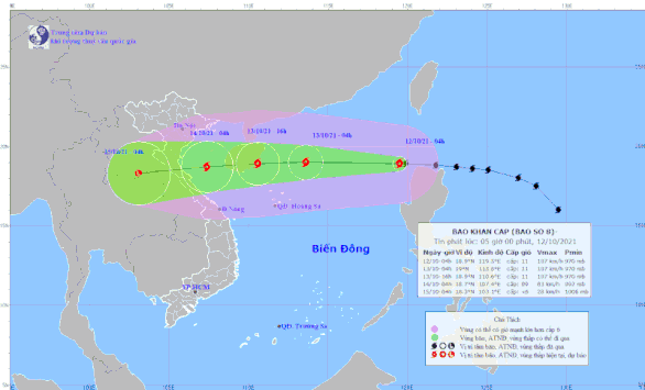
After entering the East Vietnam Sea on Tuesday morning, Typhoon Kompasu is moving toward Vietnam’s north-central region, with gusts expected to reach 166km per hour, the national weather center reported.
Kompasu, the eighth storm in the waters so far this year, was spotted about 720km northeast of Vietnam’s Hoang Sa (Paracel) archipelago at 10:00 am on Tuesday, the National Center for Hydro-meteorological Forecasting said.
Over the next 24 hours, the typhoon, with winds of up to 120km per hour and squalls reaching 149km per hour, is forecast to move quickly westward at 25 to 30km per hour and gather strength.
Kompasu is forecast to be centered around 140km east of China’s Hainan Island at 10:00 am on Wednesday, with gusts reaching 150 to 166km per hour.
Over the next 24 to 48 hours, the typhoon will keep traveling west at 25km per hour but tends to get weaker.
It will be located off the coast from Thanh Hoa to Quang Binh Provinces in the north-central region at 10:00 am on Thursday, with squalls decreasing to 102km per hour.
In the next 48 to 60 hours, the typhoon will move west-southwest at a lower speed of 20km per hour and land in the north-central region.
After its landfall, Kompasu will be downgraded into a tropical depression and travel to Laos.
Affected by the typhoon, the northern part of the East Vietnam Sea will have gusts of up to 166km per hour and extreme rough seas, with waves rising up to five to seven meters as early as Tuesday.
The Gulf of Tonkin and the waters from north-central Quang Tri Province to central Quang Ngai Province will also have severely rough seas and strong winds reaching 117km per hour.
During Tuesday, the middle and southern parts of the East Vietnam Sea will have southwest winds of 49 to 74km per hour and waves of up to three meters in height.
The coastal area from northern Quang Ninh Province to north-central Quang Binh Province will have winds as strong as 102km per hour from late Wednesday to Thursday.
During the same period, heavy rains of 100 to over 200 millimeters will cover the northern area and Quang Tri Province, while downpours of up to more than 300 millimeters will hit the Thanh Hoa - Quang Binh region.
Flash floods and landslides may occur in mountainous areas while inundation is likely to hit low-lying and riverside areas.
Due to the influence of the cold air combined with the tropical convergence trip, the northern and middle parts of the central region will likely have torrential rains from Friday.
During the last quarter of this year, the East Vietnam Sea will see five to seven storms or tropical depressions, of which two to four will directly affect the mainland of Vietnam, the center previously forecast.
Like us on Facebook or follow us on Twitter to get the latest news about Vietnam!

The Vietnamese rescue team has located and handed over five bodies to the families and authorities in Myanmar

'Vietnam regrets the United States' decision to impose retaliatory tariffs on Vietnamese exports'
18 hours ago
The country still faces the risk of significant seismic activity, particularly in the northwest region
21 hours ago
They are entering their final stretch of preparations for the grand military parade
22 hours ago
Good morning from Vietnam!
22 hours ago
Quang Tri was the first province in Vietnam to implement UXO clearance programs in 1996 and MIA efforts in 1998
20 hours ago
The U.S. has been Vietnam’s largest export market for years


The U.S. has been Vietnam’s largest export market for years

The Vietnamese tea and coffee market is currently witnessing the fusion of tradition and modernity

King Philippe expressed joy at returning to Ho Chi Minh City and witnessing its dynamic development since his first visit in 1994

The Ho Chi Minh City Police have launched a special 50-day-and-night campaign from April 1 to May 20 to achieve outstanding results

His death is a great loss to both nations

The boy climbed the mango tree to pick fruit and fell fast asleep on the branches

The Ho Chi Minh City government has converted the Saigon Zoo and Botanical Gardens' land lease into a public land allocation

Construction began on the 54-hectare project in 2023

The 46-percent retaliatory tariff is expected to have broad implications for the country’s economy

Climate change deniers are pushing an AI-generated paper questioning human-induced warming


