Powerful storm Trami approaching central Vietnam
Saturday, October 26, 2024, 10:20 GMT+7

Trami, the sixth tropical storm to hit the East Vietnam Sea this year, is heading toward central Vietnam before likely changing its direction to go back to sea, according to the National Center for Hydro-Meteorological Forecasting.
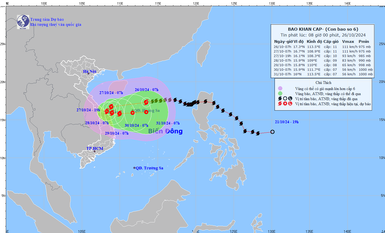
As of 7:00 am on Saturday, storm Trami was located in the waters northeast of Vietnam's Hoang Sa (Paracel) archipelago, with winds of up to 117kph and gusts reaching 166kph.
The storm was moving westward with a speed of about 20kph.
Over the next 24 hours, Trami will go west-southwest at the same speed and it will be located in the waters off the mid-central region at 1:00 am on Sunday, with the same strong winds.
The storm will then move west-southwest and then southeast at 5-10kph and will be centered in the waters near the coast of the same region at 7:00 am next Monday, with weaker winds of 88kph and squalls of 117kph.
Over the following 24 hours, it will move at 5kph, with further weaker winds, and possibly approach the coast of mid-central localities at 7:00 am next Tuesday.
During the next 72 hours, the storm is forecast to march mainly eastward with a speed of about 10kph and continue weakening.
Because of the storm, the waters in the northern East Vietnam Sea have become extremely rough, with waves reaching up to nine meters in height, and strong winds of up to 117kph and gusts as high as 166kph.
The waters off the central coast from Quang Binh to Quang Ngai Provinces will have strong winds ranging from 49kph to 88kph and rough sea waves rising as high as five meters from Saturday evening.
This stormy weather poses significant danger to vessels at sea, the center warned.
The agency also drew more attention to protection of sea dykes and embankments from possible damage due to the powerful sea waves.
From Saturday night until next Monday, the central region from Quang Tri to Quang Ngai will have torrential rain with precipitation of 300-500mm, even 700mm in some areas.
The area from Ha Tinh Province to the northern part of the Central Highlands will also have heavy rains with rainfall of up to 300mm.
Predicting that the storm may have complicated developments in the coming time, the center called for relevant authorities, agencies, and people to keep themselves updated with the latest storm reports.
Prime Minister Pham Minh Chinh on Thursday issued a telegram asked concerned ministries and authorities to urgently make comprehensive preparations to respond to the coming storm that may affect dozens of localities, including Thanh Hoa, Nghe An, Ha Tinh, Quang Binh, Quang Tri, Thua Thien-Hue, Da Nang, Quang Nam, Quang Ngai, Binh Dinh and Phu Yen.
The National Civil Defense Steering Committee on Friday reported that 285,000 soldiers and more than 12,500 facilities, including 13 aircraft, have been mobilized to cope with the powerful storm.
Like us on Facebook or follow us on Twitter to get the latest news about Vietnam!

Around 40,000 suspected measles cases and five measles-related deaths have been reported nationwide since early 2025

Since the family of the victim did not request or receive compensation, the defendant was not entitled to any leniency
11 hours ago
They developed symptoms of sore throat, headache, nausea, and dizziness
1 day ago
She was charged with violating road traffic regulations
23 hours ago
The supercar and sport motorbike procession was part of the celebration of a company’s third anniversary
1 day ago
Many residents of high-rise buildings in Hanoi had previously complained about the smoke emissions from the textile factory
1 day ago
The first group of 58 leading U.S. firms is visiting from Tuesday to Thursday


The first group of 58 leading U.S. firms is visiting from Tuesday to Thursday

Grab and its smaller Indonesian rival GoTo have reportedly engaged in several rounds of talks over a potential merger

Each tour will last for one hour, with a capacity of 10-20 visitors

Aviation has long recognized the batteries as a safety concern

The bank saw economic growth at 2.9 percent in December

It is vital to avoid situations where businesses face excessive scrutiny and intervention just as they start to grow

Vietnamese authorities will conduct a comprehensive review to expedite the project as soon as possible

Due to its unstable condition, it was deemed too dangerous to move

One of the new images shows the Sun glowing just above the horizon, its halo tinged with green

Experts say internal constraints such as a talent crunch, funding problems and other supply chain gaps are key hurdles


