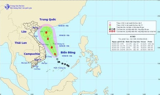
A tropical depression has developed in the East Vietnam Sea and is forecast to strengthen into a storm, according to the National Center for Hydro-meteorological Forecasting.
As of 1:00 am on Sunday, the tropical depression was located at about 410 kilometers south of Vietnam's Truong Sa (Spratly) archipelago, packing winds at 40 to 60km per hour and squalls at up to 88km an hour.
It is forecast to travel northwestward at 10km an hour and is likely to become a storm.
By 1:00 am on Monday, the typhoon is expected to be 200 kilometers southwest of Truong Sa and about 250 kilometers east of the coastline between the central provinces of Quang Nam and Quang Ngai.
Wind speed will reach between 60 and 75km per hour and gusts at up to 100km an hour.
The weather phenomenon is forecast to bring about rain and strong wind along the coast of central and southern Vietnam.
The storm will continue its northwest journey in the next 24 to 48 hours and pick up strength.
It will be located along the southern coast of China’s Hainan Island as of 1:00 am on Tuesday, packing winds of 60 to 90km per hour and traveling north.
According to a previous forecast by the National Center for Hydro-meteorological Forecasting, about one to two storms or tropical depression will form in the East Vietnam Sea in June.
Like us on Facebook or follow us on Twitter to get the latest news about Vietnam!


