Vietnam monitors Philippines-approaching Typhoon Mawar
Saturday, May 27, 2023, 09:26 GMT+7

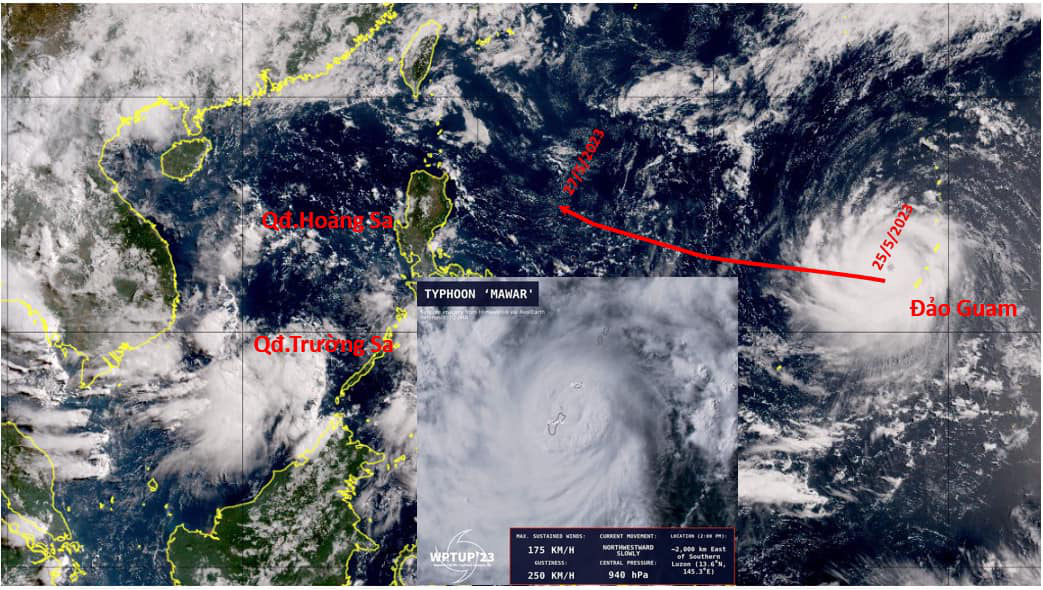
The Vietnam Meteorological and Hydrological Administration (VMHA) under the Ministry of Natural Resources and Environment is keeping a close watch on the progress of Super Typhoon Mawar, which has already moved past Guam.
Super Typhoon Mawar, the second storm active in the Pacific Northwest during the 2023 stormy season, has sustained a super typhoon level after blasting Guam, the westernmost territory of the U.S., the VMHA said on Friday.
The weather forecaster predicted that the cyclone was moving west-northwestward to the north of Luzon Island off the Philippines.
The center of the typhoon was located at 15.3°N and 138°E, packing winds of 216 km per hour, with gusts of 306 km per hour as of 3:00 pm on Friday (Japan time), according to the Japan Meteorological Agency (JMA).
The JMA forecasted that Mawar will predominantly move westward over the next 24-48 hours, maintaining its current intensity while traveling at a speed of approximately 25-30 km per hour.
Over the next 48-72 hours, the super typhoon will shift in a northwest direction and experience a reduction in intensity.
At 5:00 am on Saturday, it was about 1,320 km east of Luzon Island, according to the Philippine Atmospheric, Geophysical and Astronomical Services Administration (PAGASA).
The vicinity near the storm’s core experienced winds of 195 km per hour, with gusts reaching up to 240 km per hour.
The radius of the area with strong winds extends about 570 km from the center of the storm.
Following its trajectory toward the waters north of Luzon Island, the typhoon will subsequently alter its course and start moving in a northeast direction over the next 24 hours.
Both the JMA and the Joint Typhoon Warning Center (JTWC) of the U.S. provided similar forecasts regarding the anticipated change in direction, adding a decline in power.
The VMHA forecasted that between June and August, there will be around five to six storms and tropical depressions active in the East Vietnam Sea, which is roughly in line with the annual average.
Among these, about one to two storms are expected to directly impact Vietnam's mainland.
Approximately four to five storms and tropical depressions are in the forecast for the East Vietnam Sea between September and November, primarily affecting the central region.
While the overall storm activities may not be significant, they may exhibit anomalous characteristics in terms of intensity and trajectory, especially on the middle of the season.
Like us on Facebook or follow us on Twitter to get the latest news about Vietnam!

The Vietnamese rescue team has located and handed over five bodies to the families and authorities in Myanmar

'Vietnam regrets the United States' decision to impose retaliatory tariffs on Vietnamese exports'
20 hours ago
The country still faces the risk of significant seismic activity, particularly in the northwest region
23 hours ago
They are entering their final stretch of preparations for the grand military parade
1 day ago
Good morning from Vietnam!
1 day ago
Quang Tri was the first province in Vietnam to implement UXO clearance programs in 1996 and MIA efforts in 1998
22 hours ago
The tariff announcement drive the VN-Index down by nearly seven percent on Thursday


The tariff announcement drive the VN-Index down by nearly seven percent on Thursday

Good morning from Vietnam!

The U.S. has been Vietnam’s largest export market for years

The Vietnamese tea and coffee market is currently witnessing the fusion of tradition and modernity

King Philippe expressed joy at returning to Ho Chi Minh City and witnessing its dynamic development since his first visit in 1994

The Ho Chi Minh City Police have launched a special 50-day-and-night campaign from April 1 to May 20 to achieve outstanding results

His death is a great loss to both nations

The boy climbed the mango tree to pick fruit and fell fast asleep on the branches

The Ho Chi Minh City government has converted the Saigon Zoo and Botanical Gardens' land lease into a public land allocation

Construction began on the 54-hectare project in 2023


