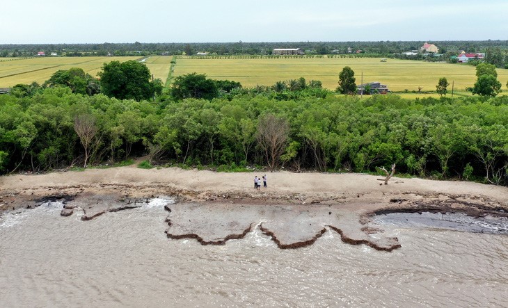
Many sections of the Bien Tay (Western Sea) dyke measuring over 300 kilometers in length in Ca Mau and Kien Giang Provinces, located in Vietnam's Mekong Delta region, are running a high risk of being damaged by waves while it plays an important part in protecting agricultural production activities and the lives of thousands of residents.
The dyke section in Ca Mau stretches a length of 108 kilometers from the Nam Canal in Rach Cheo Commune, Phu Tan District to the Tieu Dua Canal in Khanh Tien Commune, U Minh District.
The dyke protects nearly 129,000 hectares of agricultural land and over 26,000 households in Ca Mau.
However, only 51 kilometers of the dyke has been concreted, while the remaining 57 kilometers faces a high risk of collapse, threatening production and the daily life of local residents.
Huynh My Le, a resident in Khanh Hoi Commune, U Minh District, said waves have become bigger over the past three years.
Whenever waves rise for about half an hour, her house is heavily flooded despite the dyke system.
Ca Mau Province has a coastline of 254 kilometers but up to 187 kilometers has been seriously eroded, according to the provincial People’s Committee.
Coastal erosion has washed away some 5,250 hectares of land and protected forests, equivalent to the area of a commune in Ca Mau, over the past decade.
Since early this year, riverside land collapse have also sunk some 230 houses with total losses of over VND1 trillion (US$42 million).
Nguyen Tien Hai, secretary of the Ca Mau Party Committee, said the province would deal with landslide sites until 2025 amid the currently complicated climate change.
Otherwise, losses would be greater, hitting the province’s socio-economic development.
“We need some VND3.4 trillion [$142.8 million] to handle riverside landslides and coastal erosion spanning 89 kilometers. [The province] will also develop an additional seven resettlement areas to accommodate over 1,380 erosion-hit households,” Hai added.
|
|
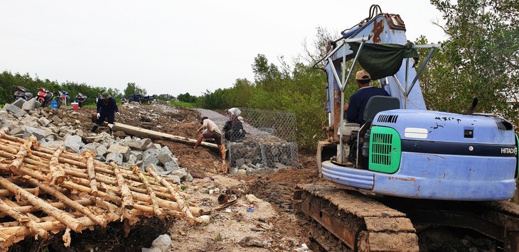
| Workers upgrade a Western Sea dyke section in Ca Mau Province, southern Vietnam. Photo: T.Huyen / Tuoi Tre |
Meanwhile, Kien Giang Province is home to some 200 kilometers of the Western Sea dyke stretching from Van Khanh Tay Commune in An Minh District to Ha Tien City.
Coastal erosion has been seen along a coastline measuring over 56 kilometers in An Bien, Hon Dat, and Kien Luong Districts as well as Ha Tien.
Most recently, strong waves triggered by rains and the southwest monsoon damaged 30 meters of the Western Sea dyke section in Van Khanh Commune in June last year, severely affecting the agricultural production on 500 hectares of land in the commune.
During a recent visit to Ca Mau, Prime Minister Pham Minh Chinh said the province was confronted by serious landslides.
At first, the province should review landslide-prone areas and take the initiative in evacuating households in these areas to safer places, PM Chinh required.
The province has expanded protected forests and coordinated with other forces to safeguard existing protected forests to prevent waves and wind from hitting coastal residential areas, according to To Quoc Nam, deputy director of the provincial Department of Agriculture and Rural Development.
The administration of Kien Giang Province also sought funds for the upgrade of the Western Sea dyke section in its precincts and the construction of a coastal road.
Besides investing in dyke and embankment systems, Ca Mau and Kien Giang have planted avicennia alba, a species of tropical mangrove, to reinforce the Western Sea dyke.
Like us on Facebook or follow us on Twitter to get the latest news about Vietnam!


