Tropical depression likely to form in East Vietnam Sea this weekend
Thursday, June 20, 2024, 12:18 GMT+7

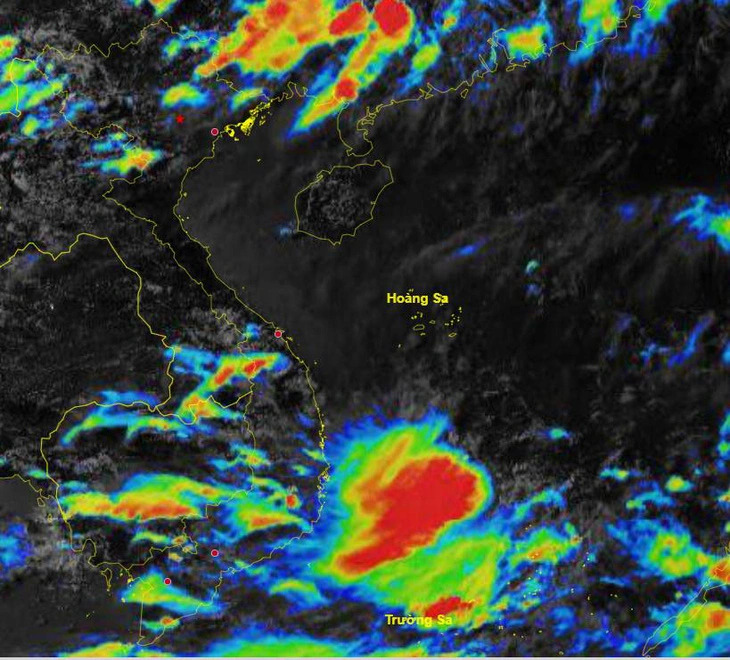
A low-pressure area is expected to appear in the northern and middle parts of the East Vietnam Sea this weekend, with a 75-percent chance of strengthening into a tropical depression and a 30-percent chance of turning into a storm, said the national weather forecast agency on Wednesday.
The possible tropical depression or storm could directly impact the northern and middle parts of the East Vietnam Sea, including Vietnam's Hoang Sa (Paracel) archipelago and the Gulf of Tonkin between June 23 and 25, bringing bad weather conditions to the areas.
The National Center for Hydro-Meteorological Forecasting added that showers and powerful thunderstorms will likely hit the middle and southern parts of the East Vietnam Sea, comprising Vietnam's Truong Sa (Spratly) archipelago and the waters from south-central Binh Dinh Province to southern Ca Mau Province, due to the impact of strong monsoon winds..
The weather agency warned of a possibility of whirlwinds, wind gusts, and high waves of over two meters during thunderstorms.
The center also noted that around seven storms and tropical depressions could hit the East Vietnam Sea from now until September, with approximately three of them making landfall.
Like us on Facebook or follow us on Twitter to get the latest news about Vietnam!

Thai officials were preparing to send her back to Poland

The company owner has been uncontactable
1 day ago
The medical team quickly located the hotel and reached out to hotel employees to rescue the foreigner
18 hours ago
The launch of the electric vehicle charging station promotes green mobility and green energy transition
1 day ago
Thai officials were preparing to send her back to Poland
20 hours ago
Good morning from Vietnam!
1 day ago
The villa is located within the planned site for a riverside road project


By October 1, water levels at Tan Chau Station on the Tien River could reach 3.38 meters, which is 0.48 meters higher than the same period last year

The villa is located within the planned site for a riverside road project

The products are water, mold, and bacteria resistant and eco-friendly

Buy now, pay later services have grown at a rate of 32 percent per year in Vietnam

Vietnam has handed over more than 1,000 sets of remains to the U.S. and helped identify 735 MIA soldiers

Good morning from Vietnam!

In just over 12 hours, the iPhone 16 became the hottest topic on social networks in Vietnam
The medical team quickly located the hotel and reached out to hotel employees to rescue the foreigner

She dedicated her special day to the band by having a BTS-themed wedding
Thai officials were preparing to send her back to Poland


