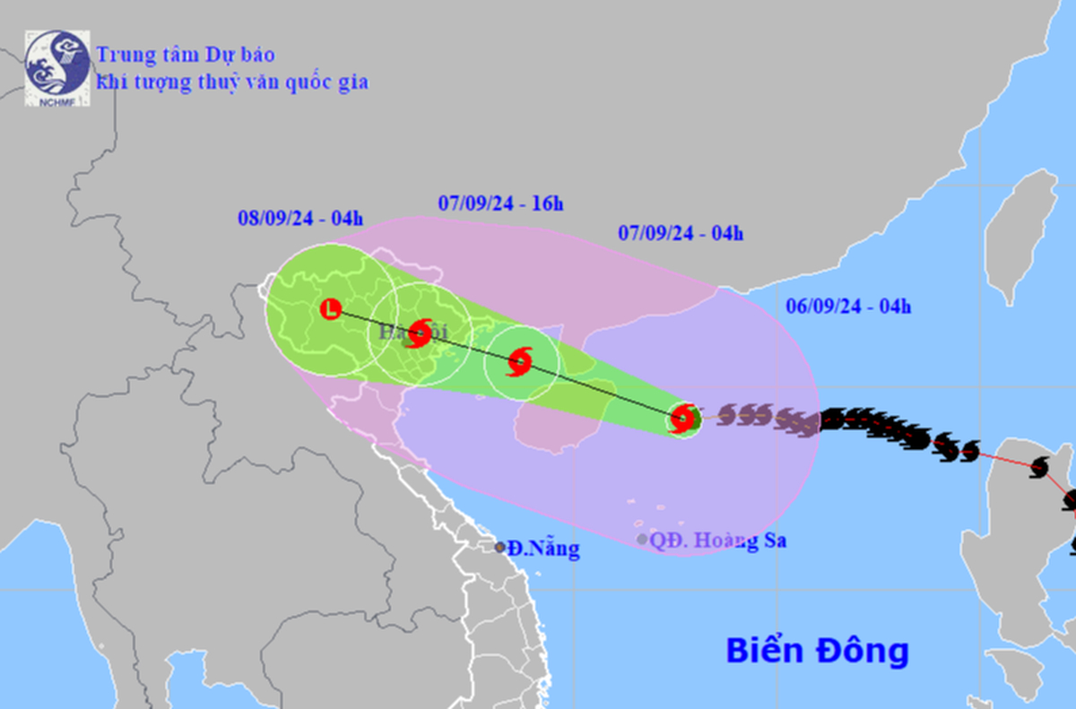
Super typhoon Yagi is forecast to sweep through China’s Hainan Island before entering the Gulf of Tonkin early on Saturday and making landfall in the Quang Ninh-Nam Dinh region of northern Vietnam, according to the National Center for Hydrometeorological Forecasting.
Yagi, the third storm to strike the East Vietnam Sea this year, was located about 168 km east-southeast of China’s Hainan at 6:00 am on Friday, packing winds of up to 201 kph and gusts over 220 kph.
The super typhoon is currently within 600 km southeast of Vietnam’s Quang Ninh Province.
The central weather agency reported that the typhoon was moving west toward Hainan at a speed of 15 kph.
Within the next 24 hours, Yagi will move west-northwest at 15-20 kph and is anticipated to pass through the northern part of Hainan before entering the Gulf of Tonkin between Friday night and early Saturday.
By 4:00 am on Saturday, the super typhoon is forecast to be within 160 kilometers east-southeast of Quang Ninh with winds reaching 166 kph and squalls of up to 220 kph.
By noon on Saturday, Yagi is predicted to reach Vietnam’s northern coastal area from Quang Ninh to Nam Dinh Provinces, packing winds of 74 kph and gusts of 117 kph.
The storm will continue on a northwestern trajectory before downgrading into a tropical depression and then a low-pressure system in northwestern Vietnam.
Affected by the typhoon, the northern part of the East Vietnam Sea will see rough waves of four to six meters high with powerful winds ranging from 103 kph to 201 kph, along with gusts reaching over 220 kph over the next 24 hours.
Winds in the eastern area of the Gulf of Tonkin will gradually increase to 61 kph from Friday noon before surging to 166 kph along with squalls of 220 kph in the evening.
Waves in the affected area will range from two to eight meters high, posing serious risks to sea vessels operating in the area.
Waters off the coastal region from Quang Ninh to north-central Thanh Hoa Province will have rough seas with waves rising up to five meters.
Residents in the region should be on the alert for high seawater that can affect boat-anchoring sites, aquaculture areas, dykes, and embankment systems.
From Friday night through Monday morning, heavy rains will hit the northern region and Thanh Hoa with precipitation of 100-300mm, even up to 500mm in some localities.
Torrential rains from Yagi could trigger flooding in low-lying and urban areas, potentially leading to rivers overflowing and landslides in hilly and mountainous regions, the center warned.
Prime Minister Pham Minh Chinh on Thursday signed an official dispatch requiring local authorities in coastal provinces and cities the northern and central regions to urgently develop plans to effectively respond to the approaching super typhoon.
Leaders of these localities, including Quang Ninh, Hai Phong, Thai Binh, Nam Dinh, Ninh Binh, Thanh Hoa, Nghe An, Ha Tinh, Quang Binh, and others, were ordered to postpone non-urgent meetings to mobilize the entire political system and resources to cope with the storm.
Earlier on Wednesday, Minister of Agriculture and Rural Development Le Minh Hoan also requested that all coastal localities in northern and north-central regions promptly take effective measures to minimize risks from the powerful storm to life, property, industrial park infrastructure, telecommunications, electricity, river dykes, and other construction works.
Like us on Facebook or follow us on Twitter to get the latest news about Vietnam!


