Towns and cities in Vietnam’s central region are expected to feel the brunt of a developing depression in the East Vietnam Sea.
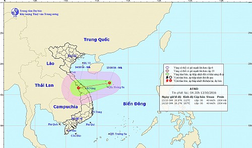
As of Thursday morning, the depression lingered over the seawaters surrounding Vietnam’s Hoang Sa (Paracel) archipelago with its center at 16.9 degrees latitude north and 112 degrees longitude east, according to the National Center for Hydro-Meteorological Forecasting.
By 4:00 am, the depression had moved to 430 km east-northeast of Quang Tri and Quang Ngai Provinces, bringing along winds of 40-50 kph as it continued to hammer its west-southwestward path, moving at 20 kph.
The climatic event is expected to cross the central area of Vietnam and sit above the border between Laos and Vietnam at 16.1 degrees latitude north and 107 degrees longitude east by 4:00 am on Friday, unleashing winds as high as 7-8 on the Beaufort scale.
Experts expect the depression to cause significant disturbances to waters in the Gulf of Tonkin, the Paracels, and the maritime areas off the coast of Quang Tri and Quang Ngai Provinces.
Due to the combined effects of the depression, northeasterly winds, and upper-air disturbances, residents in Thanh Hoa and Quang Ngai should prepare for 300-500 milliliters of rain to fall on the area between Nghe An Province and Hue City by Saturday.
Flashfloods in low areas and landslides in mountainous regions are highly imminent in Nghe An, Ha Tinh, Quang Binh, Quang Tri, and Thua Thien-Hue Provinces, the weather forecast center warned.
The phenomenon is also set to deliver rainy squalls to the Central Highlands and the southern regions over the next two to three days.


