Ca Mau loses 1.5km of land to sea over 40 yrs
Monday, December 09, 2013, 19:38 GMT+7

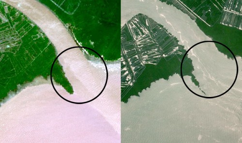
Satellite images show seawater has encroached an estimated 1.5km of land in the eastern coastal area of the southernmost province of Ca Mau over the past 40 years.
Satellite images taken from 2005 to 2010 show that in just five years, a 200m section of the eastern coastal area of Ca Mau was swallowed by seawater, according to scientists at the Vietnam National Remote Sensing Center (RSC) under the Ministry of Natural Resources and Environment (MONRE).
“In this area, coastlines are seriously eroded. Seawater is just a few meters away from a commune’s people’s committee at high tide,” said Dang Truong Giang, a scientist at RSC.
The scientists added that encroaching seawaters are occurring nationwide. Four coastal areas from Quang Ninh to Ninh Binh northern provinces have been eroded by seawater; the worst cases have been recorded in Hai Phong City’s Cat Hai District and Nam Dinh Province’s Hai Hau District.
In central Vietnam, a study shows that 50 percent of the 1-km long coastline has been eroding since 2005. The scientists record erosion of 15 to 100m per year in the region.
In southern Vietnam, coastal erosion is recorded in Ngoc Hien, Dam Doi, and Tran Van Thoi districts in Ca Mau Province, Dong Hai District in Tra Vinh Province, and rural Can Gio District in Ho Chi Minh City.
Nguyen Thanh Minh, Chief of Vietnam Administration of Seas and Islands (VASI), told Tuoi Tre the administration has finished its comprehensive study of coastal erosion across the country after two years and will present it at a conference held in Bangkok, Thailand next week.

15,300 train trips have been operated

A 7-year-old girl had allegedly been repeatedly physically abused with a heated iron bar by her father and stepmother
7 years ago
The excavator was working on a roadway when local officials enlisted it to save the day
7 years ago
Scavengers can easily be ‘swallowed’ by waves and swept away by the sea
7 years ago
'Taste of Australia is not just a culinary festival, but also a platform to highlight Australia’s world-class food and beverage industries, foster business connections, and inspire cultural exchanges'


'Taste of Australia is not just a culinary festival, but also a platform to highlight Australia’s world-class food and beverage industries, foster business connections, and inspire cultural exchanges'

Companies that issue green bonds tend to be better at reducing their greenhouse gas emissions

Toyota's top supplier Denso, for instance, agreed on February 17 to record pay hikes

Duterte, 79, could become the first Asian former head of state to go on trial at the ICC

The country spent over US$734 million importing meat in January and February

Vietnam’s coffee industry surpassed US$5 billion in export value for the first time in 2024

Good morning from Vietnam!

Shingles can also negatively affect blood sugar control, therefore diabetic patients who contract shingles have a higher risk of severe or prolonged complications

Many people expressed concern over the dangerous actions of both men

Five years ago on Tuesday, the World Health Organization announced COVID-19 had become a pandemic -- a moment when the world finally woke up to the unfolding disaster


