Quarries, hydropower project hurt scenic, int’lly recognized spots in Vietnam
Friday, August 22, 2014, 20:49 GMT+7

Over roughly the last 20 years, a nationally recognized historical relic and scenic spot in southern Vietnam’s Kien Giang Province has fallen into oblivion and suffered untold damage from adjacent quarries and cement plants.
Similarly, the heart of an internationally recognized karst plateau in northern Ha Giang Province also faces an imminent risk of damage from a hydropower project in the area.
Mo So Mountain in Kien Giang's Kien Luong District, which boasts some 20 resplendent grottos, was nationally recognized in February 1995.
According to Luong Thanh Hai, director of the provincial Department of Science and Technology, the mountain belongs to the Ha Tien-Kien Luong limestone mountain system, which is part of the province’s UNESCO-recognized, 1.1 million-hectare Biosphere Reserve and the country’s second largest of its kind.
The limestone grottos are unique across the Mekong Delta and are dubbed 'a miniature Phong Nha,' which refers to Phong Nha-Ke Bang National Park in northern Vietnam’s Quang Binh Province, which is a UNESCO World Heritage Site home to a system of awe-inspiring karst formations and grottos.
More than 20 individuals of the endangered Indochinese Silver langur have been found in the Mo So Mountain.
The Mo So grottos also served as the Vietnamese revolutionary troops’ key bases during the Anti-French Resistance War and the U.S. war in Vietnam.
Despite its picturesque landscape, historical and biological value, and tourism potential, Mo So has become neglected shortly after its national recognition.
Worse, it has sustained numerous ‘injuries’ and ‘scars’ from quarries and cement plants located right next to it.
The mountain is also riddled with garbage and stinks heavily.
According to Le Minh Hoang, director of the Kien Giang Department of Culture, Sports, and Tourism, the 22.4-hectare relic boasts a 15.6 hectare limestone area.
Up to 62 households are currently living illegally at the foot of the Mo So Mountain, including two living in the strictly protected area.
Hoang said that the provincial and district governments have yet to clear the illegal houses and relocate them so far due to lack of funds.
Phan Van Huu, 52, a self-claimed tour guide at Mo So Mountain, revealed that in recent years a number of locals have themselves built makeshift paths and hung bulbs inside the grottos to receive some 50 tourists a day.
There is even a noisy pub in one of the grottos.
Four months after Mo So earned its national recognition, the Ministry of Natural Resources and Environment licensed Sao Mai Cement Co. (now Holcim Vietnam) to exploit the quarries for material to produce cement.
In September 2007, the ministry also licensed the company to expand their prospection and mining activity to a mere 50m distance from the Mo So grottos.
According to Le Minh Hoang, director of the culture department, in the past years, several investors have eyed Mo So Mountain but were all discouraged by the quarries and the cement plants nearby, which are responsible for serious air and noise pollution as well as tremors.
Hoang added that the provincial People’s Committee and related agencies will come up with solutions to solve the problem and policies to draw investment to turn Mo So into an alluring cultural, biological tourism complex.
He noted that the first task to be done now is removing the households who are illegally living in and around the foot of the mountain and relocating them. The people will be summoned to cater to tourists after the mountain is turned into a tourism complex.
Scenic spot or water?
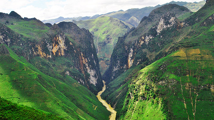
Ma Pi Leng Pass, the heart of internationally recognized Dong Van Karst Plateau in northern Ha Giang Province’s Meo Vac District, and one of the northern region’s most resplendent passes, also faces a similarly gloomy fate as the construction of Nho Que 1 hydropower project next to it is looming large.
The awe-inspiring pass offers a breathtaking view of Tu San Canyon, Southeast Asia’s deepest, and the meandering Nho Que River beneath.
The pass itself was acknowledged as a national scenic spot in 2009 and is part of the Dong Van Karst Plateau, which was recognized by the UNESCO Global Geoparks Network in 2010 as one of the 77 geological parks in the world and the second in Southeast Asia, after the Langkawi Geopark in Malaysia. The plateau remains the only one of its kind in Vietnam to earn the title so far.
Ma Pi Leng Pass is now at risk of being 'distorted' if the Nho Que 1 hydropower project kicked off construction.
The project, licensed in 2008, two years prior to Dong Van Karst Plateau’s international recognition, and worth roughly VND1 trillion (US$47.07 million), is designed to cover some 11km of the Nho Que River.
When the construction is complete, the 2km section of Nho Que River through Tu San Canyon and Ma Pi Leng Pass will have been turned into a hydropower lake.
A few months ago, under a project approved by the local government, one of the crags on Ma Pi Leng Pass, which is considered an ideal spot for tourists to have an overview of the canyon and river beneath, was leveled out and gave way to a huge concrete platform.
Amidst intense controversy, the provincial People’s Committee is set to hold a seminar in October.
The seminar, attended by local experts and UNESCO specialists in Vietnam, will assess the effects of Nho Que 1 hydropower project on Ma Pi Leng Pass and come to a decision on whether to proceed with the project.
The project has been suspended pending expert opinion and the state management agencies’ decision, the provincial People’s Committee announced.
Located at an altitude of 1,000m-1,600m, Dong Van Karst Plateau is one of the Southeast Asian country’s unique limestone areas, which contains significant imprints of the development of the earth's crust.
Up to 80 percent of the plateau’s karst formations are limestone formed by the weather through different natural developmental stages.
Chang Pung is the plateau’s oldest fossil-geological formation which dates back to 545 millions years ago.
Like us on Facebook or follow us on Twitter to get the latest news about Vietnam!

The bridge is scheduled for inauguration on April 30, 2026

A female wrester won a game at this year’s competition
7 years ago
Visitors to the event would have the chance to immerse themselves in the rich culture of Thailand
1 day ago
The magazine emphasizes its contribution to enhancing the quality of urban life
5 days ago
The contest attracted over 1,000 entries from both domestic and international participants
2 days ago
The museum occupies a 125-year-old French building that was previously the Da Nang City Hall
2 days ago
Vietnamese tourists' travel plans to Bangkok are being affected by the aftershocks of the earthquake


Vietnam Electric Cable Corporation (CADIVI) introduces lead-free and low-smoke halogen-free cables for sustainable construction

Vietnamese tourists' travel plans to Bangkok are being affected by the aftershocks of the earthquake

As of last Friday, 342 apartments had reported wall cracks

The Norwegian made amends by equalizing four minutes into the second period before being forced off with an ankle injury

Rescuers braved aftershocks to scour the devastated city of Mandalay for survivors on Monday, after a massive earthquake killed at least 1,700 people in Myanmar and at least 18 in neighbouring Thailand

The earthquake hit at a depth of 29km (18 miles) and was around 73km (45 miles) south east of the village of Pangai

The birds will be first received by the Saigon Zoo and Botanical Gardens

The country's competition watchdog said the airport operator was overcharging airlines and travellers

Spot gold prices hit a record high of $3,106.50 per ounce

The quake left around 1,700 people dead, 3,400 injured and over 300 missing as of Sunday


