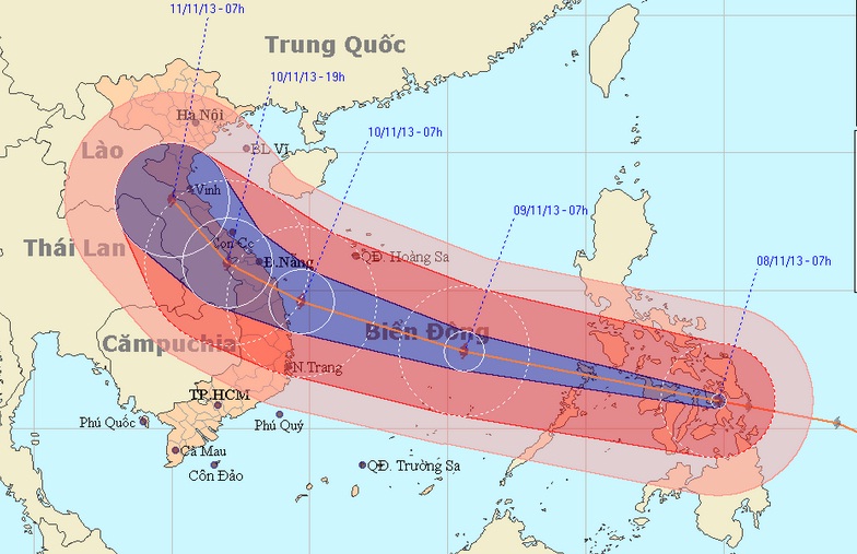
Super typhoon Haiyan, one of the strongest storms ever observed, slammed into the Philippines early Friday and will enter the East Sea early morning, heading for central Vietnam, where it may hit late Sunday or early Monday, the National Hydro-Meteorological Forecasting Center reported.
>> Super typhoon Haiyan slams central Philippines, millions seek shelter >> Super typhoon about to enter East Sea, heading for VN With sustained winds of 315 kph and gusts as strong as 380 kph, Haiyan churned across the Western Pacific into the Philippines early this morning. Thousands of people in vulnerable areas of the central Philippines have been evacuated. The super typhoon will be the most powerful storm to hit Vietnam in the past 10 years, said Bui Minh Tang, the center’s director. Along with fierce winds, the typhoon can cause sea waves to rise as high as 10-15 meters, which is very dangerous to all boats at sea, he said. At 10 am ICT today, November 8, the super typhoon was centered at 11.2 degrees latitude north and 123.7 degrees longitude east in the central Philippines, with winds near the eye reaching up to 220 kph.
Haiyan is moving between west and west-northwest at a speed of about 35 kph and at 10 am Saturday it will be seen about 190 km north-northeast of Song Tu Tay Island, part of the Truong Sa (Spratly) archipelago, with winds as powerful as 183-220 kph and with squalls of over 220 kph. Due to the super typhoon, from this evening the eastern East Sea will experience rough sea and winds as strong as 118-149 kph, which increase to 201 kph in the eye, together with squalls of over 220 kph. In the next 24 hours, Haiyan will continue to move in the same direction at 30-35 kph, towards mid-central Vietnam. At 4 am on Sunday, November 10, the super typhoon will be seen 180 km east of the coastal region between Thua Thien-Hue and Binh Dinh provinces, with winds of up to 183 kph and gusts of over 220 kph. Haiyan will later change its direction to move northwest and if the typhoon maintains its direction, it will hit the region in late Sunday or early Monday, November 11, the center warned. Minister of Agriculture and Rural Development Cao Duc Phat, head of the Central Steering Committee for Flood and Storm Prevention and Control, has requested that all local authorities in the coastal central region take measures to cope with the storm. All possible efforts must be made to ensure people’s safety while minimizing property damage, he said. All boats at sea must be kept well informed of the typhoon’s developments so that they can take safety measures in time, the committee said.


