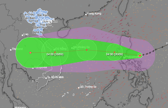
Typhoon Noru, which is moving from the east of the Philippines, is forecast to sweep through Luzon Island of the country before entering the East Vietnam Sea and heading toward central Vietnam on Monday, the central weather agency has warned.
At 7:00 am on Sunday, the typhoon was recorded around 300km east of Luzon, packing winds of 167-183 km per hour, with gusts of over 220km per hour, according to Vietnam’s National Center for Hydro-meteorological Forecasting.
Within the next 24 hours, the powerful storm is expected to make landfall on the island and slightly weaken before entering the East Vietnam Sea and moving toward the central Vietnamese region.
At 7:00 am on Monday, the typhoon will be located about 800km east of Vietnam’s Hoang Sa (Paracel) archipelago, with wind force reaching 149km per hour and squalls hitting 201km per hour.
Over the following 24 hours, the storm will move mainly to the west at a speed of 20-25km per hour and tend to get stronger.
At 7:00 am on Tuesday, the typhoon will be about 190km east of Hoang Sa, with gusts of over 201km per hour.
The storm will later move rapidly west-southwest at 25-30km per hour, heading for the central Vietnamese region.
At 7:00 am on Wednesday, the typhoon’s center is likely to be located in the area from Thua Thien Hue to Quang Ngai Provinces, with winds reduced to 89-102km per hour.
The storm will then move deeper into the mainland and gradually weaken.
Due to the influence of the typhoon, the north and middle areas of the East Vietnam Sea will have strong winds, with squalls increasing to 166km per hour, from Monday afternoon, together with rough seas with waves reaching seven meters high.
The National Steering Committee for Natural Disaster Prevention and Control chaired a meeting with relevant ministries and authorities of the coastal localities from Thanh Hoa to Quang Ngai Provinces Sunday afternoon to discuss measures to cope with Typhoon Noru.
Like us on Facebook or follow us on Twitter to get the latest news about Vietnam!


