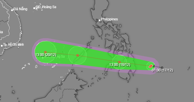
Tropical storm Jelawat, which formed in the southeastern waters of the Philippines on Sunday morning, is forecast to head toward the East Vietnam Sea after weakening into a tropical depression over the next few days, Vietnam’s national weather center said.
Jelawat was traveling westward at around 20 kilometers per hour, packing winds blowing at 65 kilometers per hour at 1:00 pm on Sunday, the National Center for Hydro-Meteorological Forecasting said in its recent advisory.
Over the next 24 hours, the storm is expected to move west-northwest, heading toward the Philippine island of Mindanao and probably downgrading into a tropical depression.
It could be located in the southern Philippines as of 1:00 pm on Monday.
With the same westward direction, the tropical depression may move at some 25 kilometers per hour, accompanied by less stronger winds at 46 kilometers per hour by 1:00 pm on Tuesday, when it could make its way toward the East Vietnam Sea.
It will likely approach Vietnam’s Truong Sa (Spratly) archipelago.
The system is anticipated to weaken further after encountering a cold front.
In the year to date, Vietnam has yet to see any direct landfall made by storms hitting the country.
Only one tropical depression landed in the central province of Thua Thien-Hue this September.
Like us on Facebook or follow us on Twitter to get the latest news about Vietnam!


