Tropical depression enters East Vietnam Sea, likely to strengthen into storm
Tuesday, September 17, 2024, 16:36 GMT+7

A tropical depression off the coast of the Philippines passed through the country’s Luzon and entered the East Vietnam Sea on Tuesday, possibly strengthening into a storm on Wednesday, Vietnam’s National Center for Hydro-Meteorological Forecasting reported.
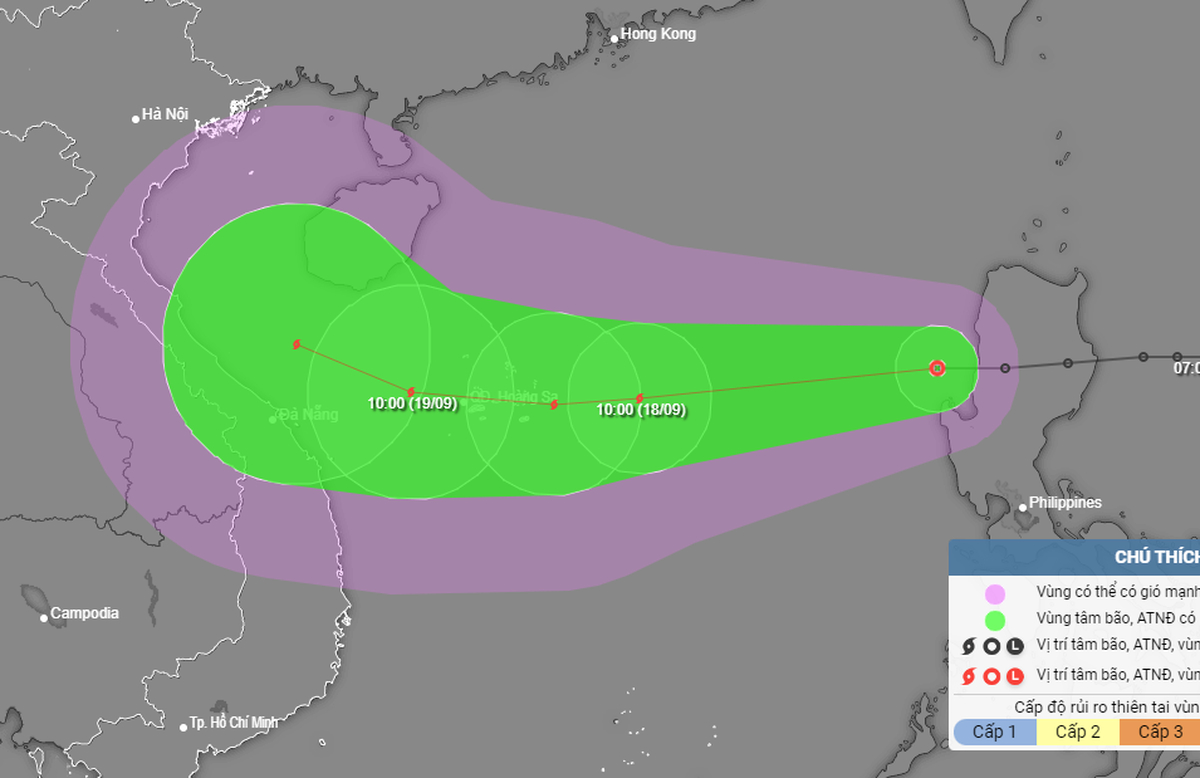
As of 1:00 pm on Tuesday, the tropical depression was located in the eastern waters of the northern part of the East Vietnam Sea, about 820 kilometers east of Vietnam’s Hoang Sa (Paracel) archipelago, with sustained winds of up to 61 kph and gusts reaching 88 kph.
Within the next 24 hours, the depression will move westward with a speed of 25 kph and probably upgrade to become the fourth storm to operate in the waters this year.
By 1:00 pm on Wednesday, the depression may be about 240 kilometers east of Hoang Sa, with the strongest wind near its center blowing at 74 kph and squalls of up to 102 kph.
The depression will then strengthen into a storm and move west-southwest at 20-25 kph.
After passing through Hoang Sa, the storm will move westward at 15-20 kph toward central Vietnam and will be centered 250 kilometers east-southeast of the coast between Quang Binh Province and Da Nang City at 1:00 pm on Thursday, with winds rising to 88 kph and gusting to 117 kph.
Over the next 48-72 hours, the storm may change its direction to move west-northwest with a velocity of 10 kph.
All international and Vietnamese forecasting systems predict that the coming storm will not be as strong as typhoon Yagi, which hit northern Vietnam on September 7, according to Nguyen Van Huong, director of the Weather Forecasting Department under the National Center for Hydro-Meteorological Forecasting.
Affected by the coming storm, the eastern waters of the northern part of the East Vietnam Sea will see rough waves of two to four meters high with winds of up to 74 kph and gusts rising to 102 kph from Tuesday, posing danger to vessels operating in the waters.
This maritime region will continue being rough with higher sea waves, reaching up to five meters, from Wednesday afternoon.
The brewing storm appears just 10 days after typhoon Yagi, the strongest storm to hit Vietnam in 30 years, devastated a series of provinces and cities in the northern region.
By 5:00 pm on Monday, typhoon Yagi and the subsequent floods and landslides had taken 291 lives, injured 1,922 people, and caused 38 others to remain missing, according to the Vietnam Disaster and Dyke Management Authority under the Ministry of Agriculture and Rural Development.
Like us on Facebook or follow us on Twitter to get the latest news about Vietnam!

Currently, Vietnam grants 45-day visa exemptions to citizens of 13 other countries, including Germany, France, Italy, Spain, the UK, Russia, Japan, South Korea, and several Nordic nations

C. asked them to remove the pet out of the area. However, instead of complying, the couple argued with the security guard
1 day ago
During the scuffle, the man wrestled the iron rod away and struck the guard on the head
19 hours ago
Phu Quoc City welcomed nearly six million visitors in 2024, including one million international arrivals
1 day ago
His 13 Facebook posts were deemed to have violated the interests of the state and individuals
1 day ago
Vietnam currently has 63 provinces and cities
22 hours ago
This year’s festival will feature cultural exchanges, trade promotion, culinary showcases, and tourism exhibitions, with the participation of approximately 150 booths


This year’s festival will feature cultural exchanges, trade promotion, culinary showcases, and tourism exhibitions, with the participation of approximately 150 booths

Good morning from Vietnam!

The association looks to ensure fair competition and stronger protections for Vietnamese steel manufacturers

MobiFone, Vietnam’s first mobile network provider, was founded in 1993 as Vietnam Mobile Services Company

Currently, Vietnam grants 45-day visa exemptions to citizens of 13 other countries, including Germany, France, Italy, Spain, the UK, Russia, Japan, South Korea, and several Nordic nations

Tax reductions would allow businesses to maintain a steady revenue flow and reinvest in operations

GPT-4.5 comes with improved ability to recognize patterns, generate creative insights without reasoning and shows greater emotional intelligence

Since 2020, he has breached more than 70 organisations, including 20 companies in Thailand

A recent $1.5-billion heist of Ethereum from the Bybit platform -- attributed by the FBI to North Korean hackers -- is believed to be the largest yet in an ever-longer litany of thefts

The robot is a prototype future 'caregiver' for Japan's rapidly ageing population and chronic shortage of aged-care workers


