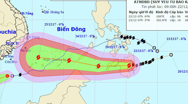
A newly formed storm is heading towards the East Vietnam Sea and is expected to impact the country’s southern region sometime over the next few days.
According to the National Center for Hydro-meteorological Forecasting, Typhoon Tembin was located in southern Philippines at 7:00 am on Friday, packing winds at 90 to 100km per hour and gusts of up to 149km an hour.
The storm is set to travel westward at 20km an hour over the next 24 hours.
The typhoon is forecast to reach 330 kilometers southeast of the Philippines’ Palawan Island by 7:00 am on Saturday, picking up speed and strength as it continues on its westward journey.
On Sunday morning, Tembin is expected to hit 440 kilometers east of Vietnam’s Truong Sa (Spratly) Archipelago with wind speeds at between 90 and 115km per hour.
The storm will then continue traveling west at a velocity of 25km an hour.
Most forecasts show that the storm could potentially make landfall in southern Vietnam on December 25 or 26
According to Le Thanh Hai, director of the National Center for Hydro-meteorological Forecasting, Tembin is a strong storm with a complicated progression.
Close supervision is required to detect any changes on its route and development, Hai added.
Meanwhile, a cold front is still active in the Southeast Asian country, bringing about low temperature nationwide.
Rough seas and strong winds are also expected to occur off the central and southern coast under the influence of the current cold spell.
A new cold span is also forecast to hit the country this weekend.
Once entering the East Vietnam Sea, the typhoon will become Vietnam's 16th storm this year.
Like us on Facebook or follow us on Twitter to get the latest news about Vietnam!


