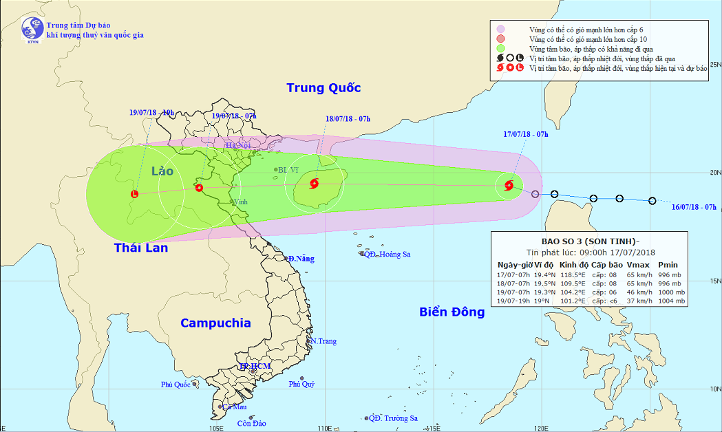
While a tropical depression off Vietnam’s north-central coast is weakening, another one has evolved into a storm after entering the northern part of the East Vietnam Sea.
The first tropical depression was located at coast between Nghe An and Ha Tinh Provinces in the north-central region as of Tuesday morning, packing winds at 40 to 50km per hour.
It will travel southwestward in the next 12 hours and weaken into a low-pressure zone, according to the National Center for Hydro-meteorological Forecasting.
Meanwhile, another tropical depression, first formed northeast of the Philippines, entered the East Vietnam Sea and become a typhoon, named Son-Tinh, on the same day.
This is the third storm to hit Vietnam this year.
As of 7:00 am, Son-Tinh was located at about 250 kilometers northwest of the Philippines’ Luzon Island, with wind speed recorded as 60 to 75km an hour and gusts at up to 100km per hour.
The storm is expected to travel northwest in the next 24 hours and located at about 350 kilometers east of the Vietnamese coast from the northern city of Hai Phong to Ha Tinh Province by Wednesday morning.
In the next 24 to 48 hours, it will weaken into a tropical depression.
The typhoon is forecast to have direct impact on provinces in northern and north-central Vietnam, especially those in coastal areas, bringing heavy downpours from Tuesday to Thursday.
In Hanoi, rainfall may be accompanied with strong gusts.
Water level of several rivers in Ha Tinh Province is rising rapidly, posing high risks of inundation, flashflood, and landslide.
Like us on Facebook or follow us on Twitter to get the latest news about Vietnam!


