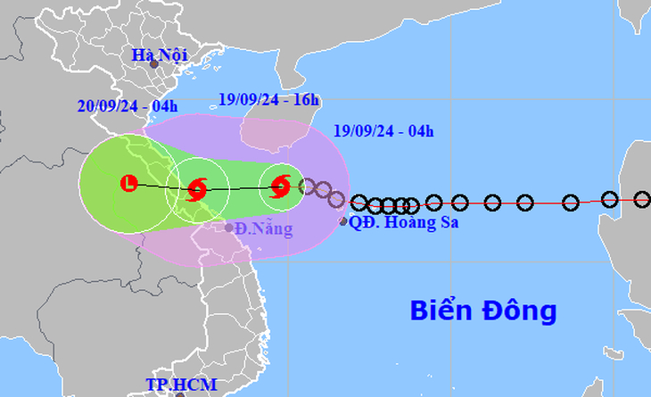
A tropical depression in the East Vietnam Sea has upgraded into a storm and is moving toward Vietnam’s central coast.
It will likely make landfall in Quang Binh and Quang Tri Provinces on Thursday evening, the National Center for Hydro-Meteorological Forecasting reported.
As of 8:00 am on Thursday, the storm – the fourth to strike the East Vietnam Sea this year – was located about 158 kilometers northeast of Da Nang and some 150 kilometers east-northeast of Quang Tri Province, carrying winds of up to 74 kph and gusts reaching 102 kph.
Over the next three hours, the storm is forecast to move westward toward the central region at speeds of 20-25 kph.
By 1:00 pm on Thursday, the storm will pass through waters off the coast of Quang Binh and Thua Thien-Hue Provinces and will likely make landfall in Quang Binh to Quang Tri Provinces later that evening, the center forecast.
After making landfall, the storm will gradually weaken into a tropical depression and then to a low-pressure system.
According to Tien Phong (Vanguard) newspaper, this storm is expected to be named 'Soulik.'
The western waters of the northern East Vietnam Sea, including the area around Vietnam’s Hoang Sa (Paracel) archipelago and the coastline from Nghe An to Quang Ngai provinces, are expected to experience winds up to 61 kph, with rough seas and waves as high as four meters.
In areas closer to the eye of the storm, waves may reach five meters high, winds will reach 74 kph, and squalls will reach 102 kph, posing significant safety risks for vessels operating in the area.
The coastal areas from Ha Tinh to Quang Nam will face similarly strong winds, while inland regions are expected to experience gusts of up to 61 kph.
Rainstorms, accompanied by powerful winds, could uproot trees, topple large advertising panels, and damage metal roofing.
Due to the impact of the storm, Quang Tri Province, Thua Thien-Hue Province, and Da Nang will see rainfalls of over 150mm for six hours on Thursday morning.
The storm will also bring downpours to the northern and middle parts of the central region, with precipitation ranging from 100mm to 300mm, and even possibly over 500mm in some areas from Thursday to Friday.
The Central Highlands and southern regions will see moderate to heavy rain on Thursday, with rainfalls of over 70mm.
All coastal provinces from Quang Binh to Quang Nam Provinces should be alert to possible damage to dykes and embankments; landslides; and flooding in low-lying areas due to torrential rains combined with strong winds, the center warned.
Heavy rain will likely cause flooding in populated urban areas where great rainwater volumes exceed the capacity of drainage systems.
In a dispatch issued on Wednesday, Prime Minister Pham Minh Chinh directed all localities expected to be affected by the coming storm to urgently take measures to effectively respond in order to minimize damage.
Authorities of all coastal provinces and cities in central Vietnam have deployed measures to cope with the coming storm.
The Thua Thien-Hue Province administration has decided to allow students to stay at home from Thursday morning until further notice.
The Civil Aviation Authority of Vietnam has temporarily suspended operations at Dong Hoi Airport in central Quang Binh Province, from 3:00 pm to 10:00 pm on September 22 to avoid possible impacts from the storm.
Like us on Facebook or follow us on Twitter to get the latest news about Vietnam!


