Yale University’s 1841 maritime map set and interpretations by Chinese scholars
Wednesday, August 26, 2015, 09:45 GMT+7

Editor's note: The following piece is written by Vietnamese scholar Pham Hoang Quan and translated by David Brown and Le Vinh Truong.
Due to historical circumstances, many national, local or regional maps and nautical charts drawn by old-time Chinese were dispersed throughout the world. Most of them have been kept in Western and Japanese libraries. Among these, maritime and nautical maps have attracted the attention of international research circles.
For example, in September 2011, the Bodleian Library of Oxford University announced publication of a digital version of "The Selden Map of China", a Ming Dynasty maritime map collected by John Selden (1584- 1654). Since the announcement, many studies of this map have appeared. These include “The Selden Map Rediscovered: A Map of East Asian Chinese Shipping Routes” by Robert Batchelor (Imago Mundi: The International Journal for the History of Cartography [Volume 65, Issue 1, 2013], a book, Mr. Selden’s Map of China by Timothy Brook (2014), and The Selden Map of China – A New Understanding of the Ming Dynasty by Annie Nie Hongbing (both a Chinese and English translation were published by the Bodleian Libraries of Oxford University in 2014)[1].
The Yale University 1841 Maritime Map Set
Recently, a Qing dynasty maritime atlas preserved at Yale University’s Sterling Memorial Library has also attracted no less scholarly interest. An English language explanation attached to the set of maps explained that the commander of the Royal Navy ship HMS Herald acquired this atlas from the sailors of a Chinese merchant ship in 1841.
This set of maps is hand-drawn, with neither title nor author name. Although not circulated in digital copies, this atlas has been photographed in full by many researchers. Taiwanese scholar Lee Hong-chi (李弘祺) saw it in 1974 while he was teaching in the U.S.
In 1997, Lee wrote two papers introducing the Qing atlas. One was published in “History Magazine” (Taipei) and one in the journal “China historical actions research” Research in the Dynamics of Chinese History (Beijing), calling it an “antique Chinese antique maritime map”.
In 2008, Chen Kuo-tung (陳國棟) in an article published in the “Central Research Institute Weekly” (Taipei) called it the “Map of East Asian Seas and the Outlines of adjacent Mountains and Islands.”
Some other scholars called it by various names: “Nineteenth Century Chinese Maritime Map”, “Chinese Qing Dynasty Sailing Vessel Map”, “The Yale Qing dynasty maritime map”, “A Chinese map of sailing routes from North Zhili to the Singapore Straits”, and “Qing Dynasty southeasterly sailing routes”.
Western scholars who have studied this atlas refer to it as the “Yale Navigational Map 1841”.
At scientific conferences in Taipei Transportation University (06/06/2010), in his delivery, Professor Stephen Davies (Director of The Hong Kong Maritime Museum) called the set “the Yale Maps.” Professor Geoff Wade (Southeast Asia Research Centre, National University of Singapore) calls it the “Yale University Chinese Navigational Map Book”.
The titles mentioned above are provided for the convenience of readers who want to find out more.
“Yale Navigational Map 1841” is a 123-page atlas. On 122 pages are Chinese illustrations of various localities and one page in English added by the library on the provenance of the map.
The areas delimited are wholly within the East Asian and Southeast Asian seas. The map drawers took Nanao Port (at the Guangdong-Fujian border) as the base point (or point of departure) describing many sea lanes, some heading north to Lushun, the south coast of the Korean peninsula, Tsushima Island and the Goto archipelago (Japan), others heading south as far as several ports in the Gulf of Thailand.
On each page, in addition to the names of locations, there are also notes on distances, directions between two places, the depth of channels, beaches and sandbars, visible buildings, the shapes and colors of natural objects, and so on.
Seriously wrong annotations
Egregious errors of annotation are found in the recent article “牛津 藏 明代 東西 洋 航海 圖 姐 眛 作 – 耶魯 藏 清代 東西 洋 航海 圖 推介” / A Discussion on the Qing Navigational Map Book Kept at Yale University by the two authors Qian Jiang (錢江) and Chen Jiarong (陳佳榮), which was published in the journal “海 交 史 研究 (Maritime History Studies), Issue number 2, October 2013 (page 1-101) [2]. Both authors are teaching at the University of Hong Kong, having in-depth researches in the field of maritime traffic history, and this is the minute research, an overview of the backgrounds atlas which annotated most sites inscribed on each page.
However, in the explanatory notes, the locations under East Sea of Vietnam (South China Sea), Qian and Chen on one hand nor complied with the presentation of the original map, on the other hand, neither followed the principle of study the old time materials.
These two authors kept on changing Van Ly Truong Sa and Van Ly Thach Duong (Vietnamese names in Chinese characters) into “a sequence of Xisha and Nansha” (Chinese names in Chinese characters) with the implications that they belong to China, while ancient map drawers have put the Van Ly Truong Sa group as a nearby belt /east of the Tiem But La (Cham Island), and Truong Sa Tail – Thach Duong head/ east of Ngoai La (Ly Son), pages 15, 16, 17 of the atlas expressing this point very clearly.
Although this is a form of connecting maps: on each page, the geographical features are drawn separately from the mainland coast, it is not difficult to identify geographical linkage between the group and the coastal islands in the far sea of East Vietnam Sea.
Original maps, pages 15, 16, 17:
 Page 15. Tiem But La, Ngoai La
 Page.16, Ngoai La
 page.17, Tiem But La, Thanh Du, Thao Du
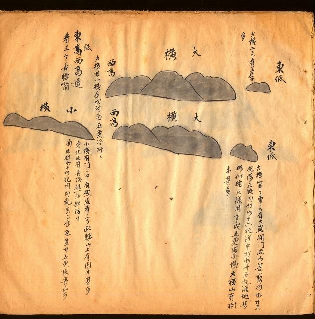
Extremely serious mistakes are in the legend of the Tho Chu Island, the outpost southwest coast of Vietnam. In Qian and Chen’s article, the main text of Section II-2, writes: “… Đại Hoành (大橫) (meaning Cambodia’s Thổ Châu Island or Poulo Panjang-with a hypothesis to be Thailand’s territory)
The original paragraph in the article of Qian and Chen, the authors, II-2:
占城大山(在越南南岸的Phan Rang 一帶)─赤坎山(在越南南岸Ke Ga角附近,一說在Phan Thiet一帶)─覆鼎(在越南東南部的Cap Saint Jacques 附近)─鶴頂(或專指覆鼎三山之一的Nui Vung Tau)─大崑崙(越南東南岸外的Condore 島)─真蒣(又作真慈、真糍﹑真薯﹑真嶼﹑大真嶼﹐指中南半島南岸外的Obi島,或稱快島﹑薯島)─假蒣(又作假慈、假糍﹑假薯﹑假嶼﹑小真嶼﹐指中南半島南岸外的假奧比即Fausse Obi 島,或稱最島)─大橫(或指柬埔寨的土珠島,即Poulo Panjang;一說為泰國的Ko Kut [注13])─小橫(或指柬埔寨的Wai 島;一說為泰國三個小島:Ko Rang、Ko Kradat、Ko Hmak [注14])─筆架山(在Bangkok 灣內,或即Khram 島;一說指
Original maps, page.73:

Page.73, Đại Hoành (大橫) Island (the island name is recognized in the Chinese maritime documents, with legend estimated to be Vietnamese Thổ Chu islands)
Here, Qian and Chen did not study marine ancient maps properly and did not view the objects in the maritime criteria or locations, instead they let the political intentions to distort the scientific objectivity.
The name Đại Hoành (大橫) in fact should have been annotated to be “the Chinese maritime record has trasformed from ancient Malay name of Panjang (that means long, high, far) into Chinese name of Đại Hoành (大橫) (big island which is situated horizontally) “.
Apparently, the Chinese has copied Malay name, because many western maritime records and maps have noted Panian, Paniang, Pinjang, Panjang very early, these names are with common stem from “panjang”.
The ancient record found in the Memorable description of the East Indian Voyage 1618-1625 of the Dutch navigator Willem Ysbrantsz Bontekoe. In this note, Tho Chu is written as “the island of Polepaniang”
Polepaniang is the combination of Pole (Poulo / islet) and Paniang,which is slightly difficult to identify.
It is easier to recognize in the map “Southeast Asia in 1675” by John Seller, or “Map of Siam in 1686” (recorded Tho Chu to be Panian), or the map, “Siam 1687” by Vincenzo Coronelli and Jean Baptiste Nollin (Tho Chu is recorded as Panjang), and to the year of 1897, in The Times Atlas in the document “Siam and the Malay Archipelago” the name of the island is not written as Panjang island as many maps before, instead it is transliterated into the appellation of Vietnam “To Chou”.
In the course of history, many islands and archipelagoes in the Gulf of Thailand have been called in the Malay language before the languages of the nations in charge. The ones who research must know that.
What’s more, he or she should only limit their transferring the location names according to the time and dynasty and/or with reference to the appellations of those locations via many languages for the purpose of recognizing an object.
Qian and Chen had overreached and worked outside the academic field when extending that the XYZ island belongs to the ABC nation.
Qian and Chen are two scholars of considerable influence in the research community of geography and history of Southeast Asia and their works are popularly cited.
Previously, serious mistakes by inferring the locality developments inappropriately for the South China Sea Islands have affected heavily with huge misunderstanding.
This time, whether on purpose or not, false annotation on Tho Chu island is the action of extremely serious provocation leading to the troubling academic environment and affecting the interest and national feeling between nations and peoples.
Chen and Qian must have reference to this article and should have rectification in the journal that you two have published the article. This is also in line with the spirit of study respect and equality mentioned in the authors’ preface.
Note
1 / Briefed on “The Selden map of China” on the BBC (10.24.2012), and detailed analysis in the journal “Research and development”, the Department of Science and Technology Thua Thien-Hue, No. 8-9, 2012, by the same author (Pham Hoang Quan)
2 / English title of the article: “A Discussion on the Qing Navigational Map Book Kept at Yale University,” Chen Qian Jiang & Jiarong.
2 / National Journal, The study of the history of overseas China in coordination with Traffic History Museum Quanzhou, based in Quanzhou City (Fujian), issues from 1978 beginning, since in 1985 to be a bi-yearly journal]

Vietnam's seafood industry, particularly catfish and shrimp, is expected to benefit from rising demand in the U.S. following additional tariffs on Chinese goods

'I can only say that Mr. Musk, what he says is absolutely factual'
20 hours ago
Their aircraft crashed during an anti-insurgency mission
20 hours ago
Arrest warrants were also issued for two Chinese nationals who were alleged 'gang leaders'
20 hours ago
Heavy rain is forecast to hit the capital and surrounding cities until March 11
1 day ago
Powerboat racing started in 1952
21 hours ago
'In more recent times, in Binh Thanh District, walking my dog was just impossible'


The blast involved a dust collector inside the Fujioka plant, which supplies auto parts to Toyota Motor

The storm is now likely to make landfall by Saturday morning near Brisbane, Australia's third-most populous city

The U.S. has historically contributed about one quarter of the total international donor funding for TB programs

'In more recent times, in Binh Thanh District, walking my dog was just impossible'

Vietnam performs over 1,000 organ transplants annually

The initiative aims to enhance urban security, maintain public order, and improve the city’s tourism image

The new feature is available to subscribers of Google One AI Premium

Each flight will carry between 238 and 531 passengers

The American footballer is known for her strength, technique, and aggressiveness

He is among the first eight qualifiers


