Storm Cimaron near East Sea causes rainstorms
Wednesday, July 17, 2013, 09:48 GMT+7

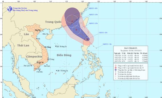
The tropical depression that was formed east of the Philippines’ Luzon Island yesterday has upgraded into a storm that is moving towards the East Sea with maximum winds of 74 kph, the National Hydro-meteorological Forecasting Center reported The tropical storm, with its international name Cimaron, will bring heavy rains to Vietnam’s central and southern provinces, the center said.
At 7 am today, the storm was centered at 18.5 degrees north and 121.6 degrees east, in a sea area north of the Luzon Island, packing winds of 62-74 kph and gusts of 87-102 kph. In the next 24 hours, the depression will move northwest at 15-20 kph and at 7 am July 18, it will be located at 21.4 degrees north and 118.1 degrees east, about 270 km southeast of the coast of the Chinese southern province of Guangdong. In areas near the storm’s eye, the win force will amount to 74 kph and gusts will reach 102 kph. The storm will continue moving northwest at the same speed and will likely change its direction to north-northeast to land in Guangdong at 7 am June 19. This morning, the storm will cause rough seas and strong winds, of up to 62 kph, to the northern area of the East Sea. Showers and thunderstorms are affecting this area. In combination with strong seasonal southwest winds, the storm will also cause rough seas in the middle and southern areas of the East Sea, including the sea of Truong Sa (Spratly), and in the region between Binh Thuan and Ca Mau provinces, with winds of 45-62 kph and gusts of 75-87 kph. Showers, thunderstorms and whirlwinds will also be seen in the sea regions. Such weather pattern is bringing widespread heavy rains to the Central Highlands region and southern provinces, and the condition will last for a few days.

15,300 train trips have been operated

The inspection team decided to continue monitoring the two foreigners to have prompt solutions
1 day ago
717 of them had officially submitted resignation requests
1 day ago
Due to his financial difficulty, he devised a plan to steal from others in order to obtain money for his needs
1 day ago
Inspectors pinpointed several violations in aircraft operations and maintenance at the air carrier
1 day ago
He was accused of accommodating a company as it illegally mined rare earths for sale to China
1 day ago
Many residents have expressed support for stricter enforcement, saying camera-based fines would create fairness and help ensure that sidewalks remain accessible for pedestrians


Many residents have expressed support for stricter enforcement, saying camera-based fines would create fairness and help ensure that sidewalks remain accessible for pedestrians

Nepali police officer Jiwan Subba still feels pangs of regret decades after he bludgeoned a strange creature he found wandering in his barn, not realising it was an endangered red panda

An engine on an American Airlines, opens new tab jet caught fire after the plane diverted to Denver on Thursday, forcing the evacuation of passengers using emergency slides, the Federal Aviation Administration said

Lows in the north are expected to range from 13 to 16 degrees Celsius

The 2015 dam collapse killed 19 people and unleashed a deluge of thick toxic mud

Civilian activists searching for missing loved ones discovered the mass grave last week in Teuchitlan, Jalisco state, along with ovens possibly used to cremate bodies

Australia is scrambling to deploy new long-range missiles

Duterte was taken into custody by the ICC in The Hague, the Netherlands, on Wednesday

The private sector contributed 42-45 percent of Vietnam’s GDP in 2023, generating 8.6 million jobs and accounting for over 70 percent of total exports, according to government data.

Good morning from Vietnam!


