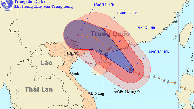
Typhoon Utor will make landfall on China’s Leizhou Peninsula today with maximum winds of 166 kph, before moving on to the Chinese province of Guang Xi and then weakening into a depression, the Vietnam National Hydro-meteorological Forecasting Center has warned. At 4 am today, August 14, Utor was centered at 20.2 degrees latitude north, 112.5 degrees longitude east, about 220 km east-northeast of the peninsula. Winds near the eye reached 134-166 kph, with gusts of 184- 220 kph. The typhoon is moving northwest at a speed of about 15 kph and at 4 pm today, it will be located at 21.4 degrees latitude north, 110.0 degrees longitude east, southeast of Leizhou. Winds near the storm’s eye will measure 150-183 kph, with gusts of up to 220 kph. After sweeping through the peninsula, the typhoon will enter Guang Xi province and weaken into a tropical depression. At 4 am on August 15, it will be located at 22.7 degrees latitude north, 110.1 degrees longitude east, in an area southeast of Guang Xi. Winds near the storm’s eye will measure 89-117 kph with gusts of 118-149 kph. Over the ensuing 24-48 hours, the typhoon will follow north-northwesterly course inside Guang Xi at a speed of 15 km and weaken into a tropical depression with winds of 39-61 kph. The depression will continue moving in the same direction at 5-10 kph before being downgraded to a low-pressure system. The typhoon will cause rough seas in the northern area of the East Sea, with violent winds of 103- 133 kph, which will increase to 134-166 kph near the typhoon’s eye, with gusts of up to 220 kph. Rough seas will also be seen north of Hoang Sa, with maximum winds of 50-74 kph and gusts of 75-102 kph. The Tonkin Gulf will have winds of 38-74 kph, and gusts of 75-102 kph. Due to the typhoon, as of tonight torrential rain will drench northeastern provinces and then spread to the mountainous northern provinces. The heavy rains will last until the 17th and could result in rainfall totals of 200-300 mm. In the northern midland delta and Hanoi, rainfall totals may be 100 mm and 50-100 mm respectively. The storm, in combination with strong seasonal southwest winds, will also cause rough seas in the middle and southern areas of the East Sea, including around the Truong Sa (Spratly) archipelago, and in the region between Binh Thuan and Ca Mau provinces, with winds of 29-49 kph and gusts of 50-74 kph. Showers and thunderstorms, possibly together with whirlwinds, will occur in these areas. The Central Steering Committee for Flood and Storm Prevention has asked concerned agencies and local authorities from Quang Ninh to Nam Dinh Provinces to keep all boats at sea informed of the typhoon’s movements so that they can take safety measures in time.
More

Residents support resuming nuclear power project in south-central Vietnam
The Ninh Thuan authorities asked 1,000 residents for their opinions on the revival of the nuclear power project
Read more

Owner of dog meat restaurant in Vietnam dies of rabies
This man had regularly handled and butchered dogs and cats at his establishment
4 days ago
Filipino arrested 20 hours after alleged theft in north-central Vietnam
The victim was another Filipino national
1 day ago
Storm Pabuk shifts toward south-central Vietnam waters
Over the next 12 hours, the storm is anticipated to weaken into a tropical depression
1 day ago
Vietnam’s Tay Ninh needs $186mn for first phase of proposed airport
The project is set to get off the ground during the 2026-30 period
22 hours ago
Artistic lighting to illuminate Ho Chi Minh City's Ba Son Bridge by year-end
The artistic lighting system installation is expected to be completed before December 31
1 day agoHighlights

EU tightens control on Vietnamese durians over excessive pesticide residues
This decision comes as part of stricter measures to ensure compliance with EU safety regulations
Latest news

EU tightens control on Vietnamese durians over excessive pesticide residues
This decision comes as part of stricter measures to ensure compliance with EU safety regulations

2 Iranians arrested for banknote scam, theft in southern Vietnam
They pretended to ask about the value of Vietnamese bills and then stole money from victims

Scientists observe 'negative time' in quantum experiments
'Negative time' exists in a tangible, physical sense, deserving closer scrutiny

Tears, prayers as Asia mourns tsunami dead 20 years on
Ceremonies were held across Asia to remember the 220,000 people who were killed two decades ago

Vietnam’s rice export price lowest in 19 months
The export price of Vietnam’s five-percent broken rice dropped US$17 to $485 per metric ton

Intense cold weather in northern Vietnam expected to persist into early 2025
Hanoi residents will experience chilly weather, with lows of 12-15 degrees Celsius

Dead body found in wheel well after United flight lands in Hawaii
It is not clear how or when the person accessed the wheel well

Seasonal blooms patterned on Eastern ceramics at Ho Chi Minh City exhibition
The exhibition runs until the end of March

Azerbaijan Airlines plane crashes in Kazakhstan, killing 38
Twenty-nine survivors received hospital treatment

Vietnam keeps facilitating overseas citizens' investment, business in homeland: Deputy PM
Deputy Prime Minister and Minister of Foreign Affairs Bui Thanh Son requested relevant agencies to make proposals and streamline policies and regulations


