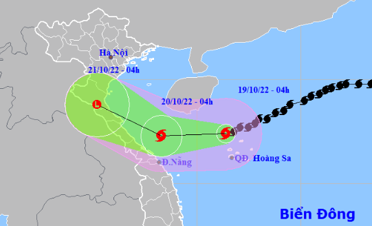
Storm Nesat began to weaken after interacting with an enhanced cold front early on Wednesday morning and is expected to be downgraded to a tropical depression over the next couple of days, Vietnam’s National Center for Hydro-meteorological Forecasting reported.
As of 4:00 am on Wednesday, Storm Nesat was located above the maritime area north of Vietnam's Hoang Sa (Paracel) archipelago, packing winds of 89-117km per hour.
It is forecast to travel southwest and further weaken over the next 24 hours.
The storm will be situated 120 kilometers east of the localities between Quang Binh and Thua Thien-Hue Provinces in north-central Vietnam.
The average wind speed will decrease to 62-74km an hour.
Nesat will travel northwest in the next 24-48 hours and be downgraded to a tropical depression and later a low-pressure area.
The Japan Meteorological Agency also predicted that the storm will weaken into a tropical depression off north-central Vietnam over the next 24-48 hours.
However, the storm will still cause heavy rains, strong winds, and high waves in the northern part of the East Vietnam Sea.
As of Wednesday, the enhanced cold spell had already influenced the weather conditions in northern localities as well as north-central Thanh Hoa Province.
Due to the combined effect of the cold snap and the circulation of Storm Nesat, medium to heavy rains will dampen northern and north-central Vietnam from Wednesday afternoon through Thursday.
Starting Thursday night, the average lows will drop to 16-18 degrees Celsius in the Red River Delta and Thanh Hoa Province and 13-15 degrees Celsius in mountainous areas.
Like us on Facebook or follow us on Twitter to get the latest news about Vietnam!


