Storm Kompasu to enter East Vietnam Sea on Tuesday
Monday, October 11, 2021, 13:33 GMT+7

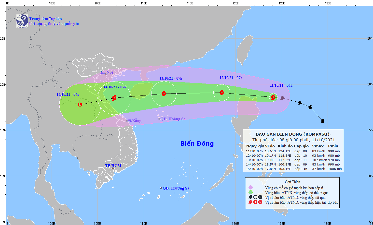
Tropical Storm Kompasu, which is moving quickly east off the Philippines, will reach the East Vietnam Sea on Tuesday morning to become the eighth storm so far this year, the national weather agency reported.
The storm was spotted 250km east-northeast off Luzon Island of the Philippines at 7:00 am on Monday morning, packing winds of up to 90km per hour, the National Center for Hydro-meteorological Forecasting said.
Kompasu is traveling fast, at 20 to 25km per hour, and will enter the East Vietnam Sea on Tuesday morning as it continues to gather strength.
At 7:00 am the same day, the storm is expected to be located around 700km east northeast off Vietnam’s Hoang Sa (Paracel) archipelago, with winds at 75 to 100km per hour.
Over the next 24 to 48 hours, Kompasu is forecast to move west at 25km per hour and keep getting stronger.
It is expected to be 150km off China’s Hainan Island, with winds as strong as 120km per hour, at 7:00 am on Wednesday.
The storm is forecast to shift west-southwest at the same speed and move off the coast between Thanh Hoa and Quang Binh Provinces in the north-central region.
Affected by the coming storm, the northeastern part of the East Vietnam Sea will have rainstorms with strong winds of up to 117km per hour, and extreme rough seas with waves rising to four to six meters as early as Monday.
The Gulf of Tonkin and the middle and southern parts of the East Vietnam Sea will have strong showers and thunderstorms, possibly with whirlwinds and squalls.
On Sunday afternoon, the seventh storm in the East Vietnam Sea so far this year, Lionrock, was downgraded into a tropical depression before landing in the region between Hai Phong City and Nam Dinh Province in the northern region on Sunday afternoon.
The depression continued weakening into a low-pressure system before dissipation.
Affected by the remaining eyewall of Lionrock, combined with a strengthened cold front, the northern region will continue having rains with precipitation ranging from 30 to 120 millimeters or higher on Monday.
The region will also experience colder weather between 19 and 22 degrees Celsius, even 18 degrees Celsius in mountainous areas.
The Central Highlands and southern regions will have medium to heavy rains, at 100 to over 250 millimeters, because of the strong southwest monsoon.
Flash floods and landslides may occur in mountainous areas while inundation is likely to hit low-lying and riverside areas.
The center previously forecast that five to seven storms or tropical depressions will appear in the East Vietnam Sea during the last quarter of this year, of which two to four will directly affect the mainland of Vietnam.
Like us on Facebook or follow us on Twitter to get the latest news about Vietnam!

Man-yi is estimated to enter the East Vietnam Sea around November 18

This was the result of an expanded probe into a cross-border network to traffic in narcotics from France into Vietnam through airports
1 day ago
He has asked that the public stop filming, photographing, or sharing his images on social media
17 hours ago
The under-construction Long Thanh International Airport will receive 80 percent of international passengers from Tan Son Nhat International Airport
1 day ago
They allegedly took turns visiting the maternity department of Hoa Binh Provincial General Hospital
1 day ago
Man-yi is estimated to enter the East Vietnam Sea around November 18
2 days ago
Vietnam has a large, potential market and is a favorable destination for the current shift of supply chains


Vietnam has a large, potential market and is a favorable destination for the current shift of supply chains

Over 140 companies from 27 countries have applied to participate as exhibitors at the expo

The coal supplier also proposed using 45 hectares of land in an economic zone to develop a system of closed coal storage and a coal screening, grinding, and blending system

The fest is set to last until December 30

The funds will be allocated to support hospitals, patients, those in need, and provide scholarships for students in Ho Chi Minh City and the surrounding provinces

'This wasn't a choice I made for him. This is something people have talked to with him, his family, his parents and just try to figure out what the best route for him is'

The investment will boost the company's OLED display output at its Hai Phong factory

The city approved a resolution establishing criteria, sectors, and guidelines for the controlled testing of drones and unmanned vehicles

Until recently aerospace engineer Pedro Monteiro figured he’d join many of his peers moving from Portugal to its richer European neighbours in the quest for a better-paid job once he completes his master’s degree in Lisbon

The city envisions future air routes to China’s Yunnan and Chongqing


